Midwater Assessment & Conservation Engineering Program
Winter Surveys in the Gulf of Alaska and Southeastern Bering Sea Near Bogoslof Island
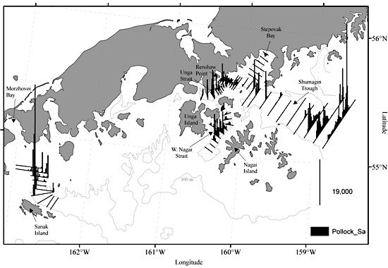
Figure 7. Acoustic backscattering (sA) attributed primarily to walleye pollock (vertical lines) along transects during the 11-21 February 2009 acoustic-trawl surveys of the Shumagin Islands and Sanak Trough in the Gulf of Alaska.
Scientists from the Midwater Assessment and Conservation Engineering (MACE) Program conducted winter echo integration-trawl surveys aboard the NOAA ship Oscar Dyson in the Gulf of Alaska (GOA) and southeastern Bering Sea near Bogoslof Island. The surveys provide data on the abundance, distribution, and biological composition of spawning walleye pollock (Theragra chalcogramma). Areas surveyed in the GOA during 11-21 February included the Shumagin Islands and Sanak Trough (Fig. 7) and the GOA shelfbreak between Sanak and Unimak Islands (not pictured). Between 19 March and 1 April, GOA surveyed areas included the Chirikof shelfbreak, Shelikof Strait, and Marmot Bay (Figs. 8-9). The area in the vicinity of Bogoslof Island in the Bering Sea was surveyed from 7 to 15 March (Fig. 10). All surveys were conducted 24 hours per day.
Survey results indicated that walleye pollock abundance increased in 2009 compared to 2008 in the Shumagin Islands area, in Sanak Trough, and in the Shelikof Strait area but decreased dramatically along the GOA shelfbreak in the vicinity of Chirikof Island. The densest walleye pollock aggregations were located in the southern part of Shumagin Trough, off Renshaw Point, along the western sides of the Sanak Trough (Fig. 7) and shelf to the west, within Shelikof Strait proper between Cape Kuliak and Wide Bay, and west of Spruce Island in Marmot Bay (Fig. 8). Few pollock were encountered in the two shelfbreak areas surveyed. Moderate to dense aggregations of Pacific ocean perch (Sebastes alutus), however, were found over much of the Chirikof shelfbreak over bottom depths of 200-300 m (Fig. 9).
In the Shumagin Islands area, 11-cm fork length (FL) mode (age-1), 21-cm FL mode (age-2), and 27-cm FL mode (age-3) fish were most abundant. In the Shelikof Strait area, the size composition consisted of a mixture of age-1, age-2, and older adult fish, with older fish dominating the deepest part of the strait between Cape Kuliak and Wide Bay and younger fish dominating elsewhere. The size composition for Sanak Trough was unimodal, with most fish between 50- and 65-cm FL. The size composition for Marmot Bay was dominated by a strong mode at 39-cm FL, with older fish ranging between 45- and 70-cm FL. Preliminary analysis of maturity stages indicated that survey timing was appropriate for all areas except Sanak Trough, where an earlier survey would be better.
The 2009 walleye pollock abundance estimate in the southeastern Aleutian Basin near Bogoslof Island was lower than the estimate from our previous survey of this area in 2007. Most of the adult pollock were concentrated north of Samalga Pass with a minor component distributed northeast of Umnak Island (Fig. 10). The pollock size composition ranged between 41-cm and 70-cm FL in both areas and was characterized by a dominant mode at about 55 cm FL. Preliminary analysis of maturity stages indicated that the majority of female pollock were prespawning in both the Samalga and Umnak regions, indicating that the survey timing was consistent with historical efforts.