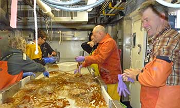
The Recruitment Processes Program had a busy summer field season in the eastern Bering and Chukchi Seas. The program collaborated on an age-0 walleye pollock and ecosystem survey in the eastern Bering Sea with the AFSC Ecosystem Monitoring and Assessment and the Midwater Assessment and Conservation Engineering Programs and the Pacific Marine Environmental Laboratory’s Ocean Ecosystem Research Division (the PMEL part of the FOCI Program) aboard the NOAA ship Oscar Dyson from 16 August through 14 October (Fig. 6). Each program brings a wealth of experience and expertise to this newly collaborative survey. In addition to determining the number, distribution, and condition of age-0 walleye pollock, benthic sampling was undertaken at night to begin determining the number, distribution, and habitat types used by age-0 flatfish such as yellowfin and flathead sole. The cruise also occupied the 70-m isobath transect, one of our sentinel monitoring lines to examine changes in the north-south distribution of water properties and plankton.
Figure 6. Members of the Recruitment Processes, Ecosystem Monitoring and Assessment, and Midwater Assessment and Conservation Engineering Programs work together to process a survey trawl catch from the eastern Bering Sea. This particular catch yielded many large jellyfish (Chrysaora melanaster). Photo by Janet Duffy-Anderson.
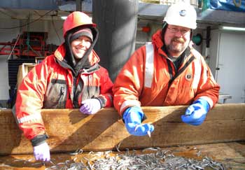
Figure 7. AFSC scientists sort small pelagic fishes from a surface trawl in the Chukchi Sea during Leg 1 of the cruise. Photo by Alex Andrews.
The four programs also collaborated on a large-scale midwater survey of the northern Bering and Chukchi Sea’s using the chartered vessel F/V Bristol Explorer. This vessel worked from 1 August to 28 September occupying a grid of stations. Recruitment Processes is responsible for analyzing the distribution and abundance of larval fish, while other groups are determining the hydrography and water column chemistry, and the distribution and abundance of phyto- and zooplankton and pelagic fishes (Fig. 7).
A second vessel chartered by the AFSC Groundfish Assessment Program conducted bottom trawls at the main gridpoint stations. The data from the two ships will be used to create an ecosystem perspective of the northern Bering and Chukchi Seas and will be compared to surveys from previous years to understand whether or not significant changes are occurring due to loss of summer sea ice. Note that the summer arctic ice was at a record low during this past summer, although the prevailing winds transported first year and multi-year sea ice into our sampling region during the surveys.
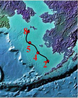
The Recruitment Processes Program is collaborating with the National Marine Mammal Laboratory (NMML) and the Pacific Marine Environmental Laboratory (PMEL) on an examination of the linkages between climate, sea-ice, krill, and baleen whales in and around oil and gas lease sites in the Chukchi Sea, (the CHAOZ project—Chukchi Acoustics, Oceanography, and Zooplankton). With funding from the U.S. Bureau of Ocean Energy Management (BOEM), the group conducted shipboard sampling and observations of physics, lower trophic levels and marine mammals on the R/V Aquila (8 August – 5 September).
The project is also responsible for maintaining moorings with biophysical instruments that sample year round for things such as water temperature, ice thickness, amount of sunlight under the ice, nutrient concentrations, krill size and abundance, and the presence/absence of vocalizing marine mammals. This is important because the region is inaccessible for much of the year to most research ships, except ice-breakers. Thus without moorings we would only be able to monitor the environment during the ice-free summer.
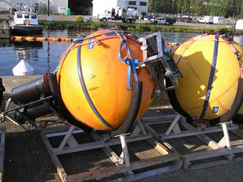
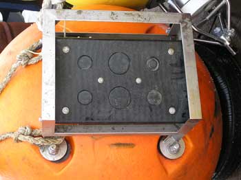
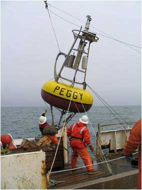
Figure 8. Newly built six-frequency acoustic device. This is a joint project between AFSC and PMEL to design, build, and utilize these instruments in the Chukchi and eastern Bering Seas. Left: Instrument mounted in a buoy. The buoy is sitting in a cradle on the dock waiting to be loaded onto the R/V Aquila. The instrument consists of a dark colored PVC block with six transducers (on top of the buoy), an electronics case containing the computer that operates the instrument and two battery cases (all below the buoy-left side of picture). In this figure the transducer faces are covered with foam for protection before deployment. Right) Close-up of transducers (50 to 735 kHz) mounted in PVC block. Photos by Jeffrey Napp
One of the instruments deployed is our newly built six-frequency acoustic profiling device (Fig. 8). Patterned off the Tracor Acoustic Profiling Systems Next Generation instruments (TAPS6-NG), these instruments use a suite of six acoustic frequencies to estimate the size and abundance of krill in the water column at the mooring sites. This information is important to help us determine food availability for the protected bowhead whales that migrate through this region twice each year. During the cruise PMEL also serviced the four
sentinel moorings in the eastern Bering Sea which are used to detect change in this highly productive ecosystem (Fig. 9).
Figure 9. Sentinel moorings in the eastern Bering Sea maintained by NOAA’s Pacific Marine Environmental Laboratory . Left: Location of eastern Bering Sea moorings. Right: Surface buoy with meteorological instruments deployed at M2 during the summer.
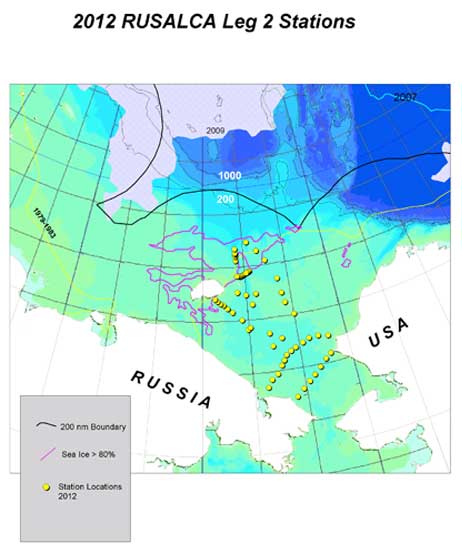
Last, but not least, the Recruitment Processes Program obtained ichthyoplankton samples from the Russian-U.S.A. Long-Term Census of the Arctic cruise (RUSALCA; http://www.arctic.noaa.gov/aro/russian-american). This was the third biological cruise for RUSALCA. Previous cruises were in the summer of 2004 and 2009. A cooperative agreement between the two countries allows sampling on both sides of the international dateline and provides us with the samples necessary to better understand the dynamics of the Chukchi Sea ecosystem, which spans the territorial waters of both countries. This year’s cruise aboard the R/V Professor Khromov (23 August – 16 September) spent most of its time sampling on the western side of the Chukchi Sea (Fig. 10).
Figure 10. Station map for Leg 2 of the 2012 RUSALCA cruise where ichthyoplankton samples were collected for the Recruitment Processes Program. Comparison of this year’s and past year’s stations can be made by going to the Ichthyoplankton Cruise Database and searching for station maps from the cruises 1KR09 and 1KR04.