NMML Researchers Census Harbor Seals Along Coastal Alaska
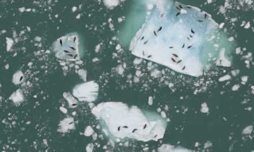
Figure 3. Image of harbor seals hauled out on tidewater glacial ice in LeConte Bay taken with the forward-motion-compensating (FMC) camera array.
NMML’s Polar Ecosystems Program (PEP) is responsible for monitoring and estimating the abundance of harbor seals in Alaska. The PEP conducts aerial surveys of harbor seals every July/August during the seals’ annual molt, when they haul out of the water while shedding and growing new hair. The 2010 surveys were conducted from the last week in July through the end of August. We utilized six aircraft, including three NOAA twin-engine planes (one AC-Shrike and two DHC-Twin Otters) and three chartered single-engine floatplanes. The scientific crew was made up entirely of NMML employees and contractors with a significant amount of aviation safety and survival training.
Harbor seals range from Southeast Alaska through the extent of the Aleutian Islands and north into Bristol Bay. Prior to 2008, for logistical purposes, Alaska was divided into five regions—Gulf of Alaska, northern Southeast Alaska, southern Southeast Alaska, Aleutian Islands, and the north side of the Alaska Peninsula and Bristol Bay—and one region was surveyed each year. Beginning in 2008, the PEP developed and implemented a new system that allows annual surveys across the entire range of harbor seals in Alaska. In 2010, the survey sites were prioritized by incorporating harbor seal stock divisions. We focus on surveying sites that make up a significant portion of each stock’s population every year. Those sites with fewer seals are flown every 3 to 5 years. This should provide us with the data necessary to estimate harbor seal population and trends on an annual basis.
The 2010 surveys also included our continued effort to monitor the population and trends of harbor seals that rely on tidewater glacier habitats for pupping and molting. During the month of August, biologists photo-sampled ice-hauling seals in tidewater glacial fjords: Icy and Disenchantment Bays in the Gulf of Alaska; Tracy Arm, Endicott Arm, and LeConte Bay in Southeast Alaska; and College Fjord and Colombia Glacier in Prince William Sound. Seals in these fjords are scattered across enormous fields of floating ice that shift with ocean and wind currents, making them difficult to count.
Due to a need for improved image quality and enhanced coverage for glacial surveys, the PEP implemented a new aerial sampling method for ice-hauling seals in tidewater glacial fjords. A three-camera, forward-motion-compensating (FMC) camera array, consisting of three Nikon D2X cameras, was mounted in the belly port of a NOAA Twin Otter. Line transects were flown by NOAA Corps pilots, and flights were timed daily to overlap with the peak abundance of seals, which occurs between 1300 and 1600 hours. This new method allowed scientists to capture higher quality imagery of seals (Fig. 3) at multiple altitudes (1,000-2,500 ft). Flight times were reduced and image quality was significantly enhanced, improving our ability to estimate population abundance and trends. The images were georeferenced and analyzed using conventional GIS software to map seal locations. The estimated total abundance is calculated using spatial statistical models. Besides abundance estimation, the high-quality imagery also allows for detailed analyses of individual seals (e.g., discriminating mother-pup pairs and population structure) and ice characteristics.
The PEP also integrated thermal image tests (alongside standard tidewater glacial surveys) for harbor seal detection using a forward-looking infrared (FLIR) camera. Additional passes were flown at 200-ft altitude increments (600-1,900 ft) over areas with high seal densities. The goals of the thermal image testing were to determine a thermal resolution threshold for harbor seals on glacial ice in order to calculate effective thermal survey altitudes and to determine thermal boundaries and sources of thermal interference for automated image collection.