Ecosystem IndicatorsNoteworthy Topics (pdf)We include information here that is deemed of relevance to ecosystem considerations of fisheries managers, but does not fit our typical indicator format. Information included here is often new, a one-time event, qualitative, or some other type of non-standard ecosystem indicator. Changes in large scale sea surface temperature patternsRecent studies have identified several large scale changes in sea surface temperature patterns and their impli- cations for climate indices. Xiao and Ren (2023) identified a regime shift in North Pacific annual mean sea surface temperature that occurred in 2013/2014. The analysis shows that within a defined area of the northern North Pacific Ocean (170°E–120°W, 45°–65°N) there were two significant and abrupt increases in annual mean temperature One occurred in 1977 and the second in 2013. This was observed in all four datasets examined: i) the fifth version of the Extended Reconstructed SST (ERSST5) (Huang et al., 2017), ii) the Hadley Centre Sea Ice and SST (HadISST) (Rayner et al., 2003), iii) the Centennial in situ Observation-Based Estimates (COBE) SST (Ishii et al., 2005), and iv) the Kaplan SSTA (Kaplan et al., 1998). The step change in 2013-2014 is also observed in the timeseries of regional satellite SST temperatures for the Aleutian Islands (Figure 18), as well as increased number of days under marine heatwave conditions (Figure 19), and coincides with increased tempera- tures recorded as part of the longline survey (Figure 22). Bottom temperatures have also increased, as shown by the increase in 2014 of the mean annual bottom temperature by region based on data from the Aleutian Islands bottom trawl survey (Figure 19, AI ESR 2022). Werb and Rudnick (2023) found that the period of persistent marine heatwaves beginning in 2014 changed the first EOF (spatial mode) and PC (principal components) of SST (calculated using data from 1950 to 2021) as compared to the established PDO spatial pattern (calculated using data from 1950 to 1993). The time series for the PDO Index became negative in 2019 (Figure 14), while the first PC of the complete record remained positive until very late in 2021. In other words, the first PC of the full time series reflected the recent warm temperatures in the eastern Pacific while the PDO Index did not. Litzow et al (2020) noted positive PDO values are increasingly associated with a large area of positive winter (November to March) North Pacific SST anomalies, shifted offshore in the northern North Pacific into a more NPGO-like pattern. These changes in large-scale spatial patterns of SST mean that past indicators such as the PDO may not be as useful in the future and that their relationships with physical and ecological processes may vary as the climate continues to change. Contributed by: Ivonne Ortiz1, Nicholas Bond 1 and Robert Suryan 2 1Cooperative Institute for Climate, Ocean, and Ecosystem Studies, University of Washington, Seattle, WA Key temperature ranges for commercial species in the Aleutian IslandsPublished optimal temperature ranges for eggs of Pacific cod, walleye pollock and Atka mackerel are provided as indicators of threshold temperatures and vulnerability to increasing temperatures in the Aleutian Islands. The optimal temperature range for Pacific cod egg hatching success above 20% is 3-6°C (Laurel and Rogers, 2020). Spawning season is from January to May, and the eggs are attached to the bottom. Larvae rise to the surface waters after hatching. By July, age-0 cod are known to settle to the bottom and inhabit the demersal, shallow waters of coastal Alaska, however, in the Bering Sea they are commonly captured across the broad shelf in both demersal and pelagic trawl surveys (Farley et al., 2016). For pollock, eggs have above 20% hatching success within a temperature range of -1 to 12 °C. Larvae are pelagic and spawning season extends from March to June. Atka mackerel spawn from late July to mid-October and eggs hatch October through January. Nesting in the Aleutians has been observed at temperatures between 3.9-10.7°C (Lauth et al., 2007), and temperatures below 3°C or above 15°C can be lethal to eggs or unfavorable for embryonic development depending on the exposure time (Gorbunova 1962). Gorbunova (962) describes the oceanic occurrence of Atka mackerel larvae in the Pacific Ocean and Bering Sea and suggests that they migrate out to sea after hatching in shallow water. Doyle et al. (1994) also found Atka mackerel larvae had an offshore distribution in the Gulf of Alaska, over the outer shelf and slope in the Kodiak Island region. Both Pacific ocean perch and northern rockfish are live-bearers, use internal fertilization and give birth to a large number of planktonic larvae (Conrath and Knoth, 2013). Parturition in Pacific ocean perch occurs in April and May (Conrath and Knoth, 2013) and from April through June (Chilton, 2007) in the Gulf of Alaska. Maselko et al. (2020) suggest long-lived marine species such as Pacific ocean perch may be resilient to environmental variability because cohorts have a genetic composition that is highly influenced by the environmental conditions experienced during their first year. Thus, they are able to maintain a portfolio of cohort-specific adaptive genotypes.
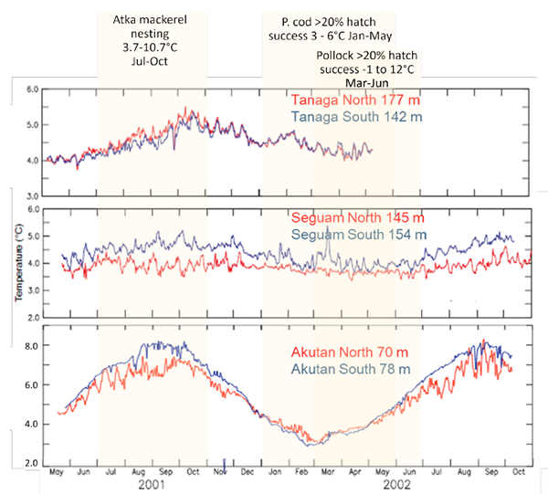
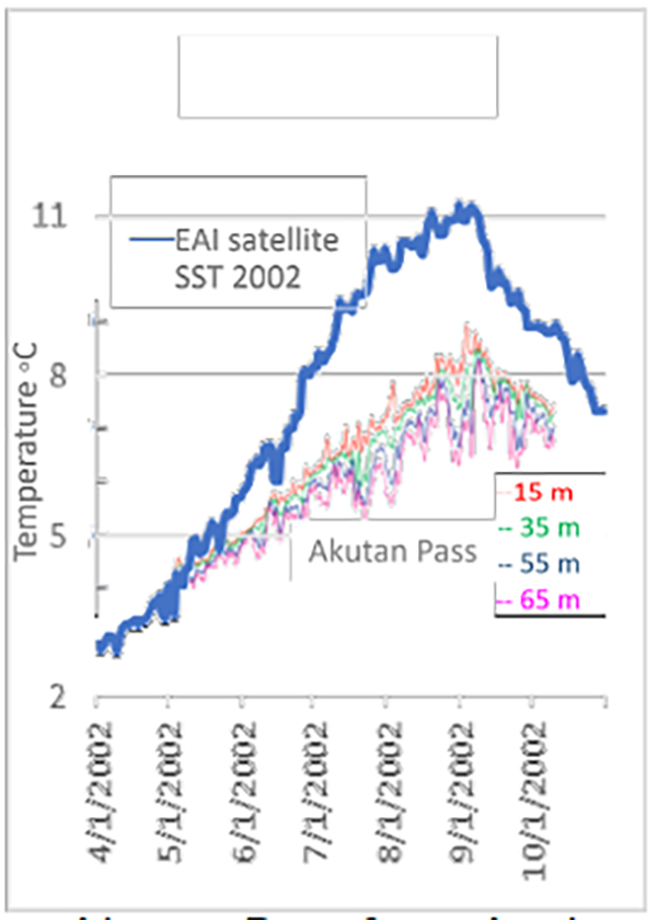
Figure 7: Bottom temperature from moorings at Tanaga, Seguam and Akutan Pass from May 2001 - October 2002 (May 2002 for Tanaga Pass) with nesting/ egg hatching period highlighted for Atka mackerel, Pacific cod (P. cod) and pollock. The only bottom temperatures available during egg development for Pacific cod, walleye pollock and Atka mack- erel. come from moorings in the Aleutian Islands and are not routinely available. However, they are useful to help interpret the data that is regularly available: 1) bottom temperature from the biennial summer bottom trawl survey, and 2) daily satellite surface temperature for the eastern, central and western Aleutians (for details on data see page 39). Based on bottom temperature time series for 2001-2002 from moorings at (west to east) Tanaga, Seguam, and Akutan Pass (Figure 7), we note three aspects: i) Seasonal variability changes with depth, longitude and differs north and south (warmer) of the islands; ii) the warmest temperatures are typically in September and October, past the summer survey, and iii) the coldest temperatures occur between February and April. A closer look at mooring temperatures at different depths in Akutan Pass in 2002 (Figure 8) shows temperatures can differ within tens of meters, particularly towards the surface. Temperatures at 15 meters can be close to 2°C warmer than those at 65 m. When comparing the mooring-based temperatures to the corresponding satellite sea surface temperatures in the eastern Aleutians, the range of satellite-derived temperatures is bigger than that from the mooring, largely due to the difference between surface and 15 m depths, but also the large area covered by the satellite estimate as opposed to the point estimate of the mooring. Still, the satellite SST is useful in providing a proxy for the seasonal change of temperatures and offers a buffered estimate of the maximum temperatures fish may experience closer to the surface. With this context, we now consider the temperatures collected during the biennial bottom trawl survey for 2002. The overall sea surface temperature had a mean 5.6°C with a range of 4.1-9.7°C (from 06/08/2002 to 08/13/2002). From the daily sea surface temperature we can get the actual maximum in that year, not captured during the survey but it does provide a maximum (not actual) temperature for shallow areas. For bottom temperatures, the survey had a mean of 4.3°C and a range of 3.3 to 5.2°C, where again we should consider the maximum bottom temperature in September October, will be above the survey maximum, and warmer at depths shallower than those sampled by the survey (typically >30 m). The overall bottom temperatures in the entire survey time series reached a maximum of 6.6°C in 2016 and a few locations in 2022, so the temperatures might have reached 7-8°C in October, September. Winter temperatures can be expected to be similar or below the maximum summer survey temperatures.
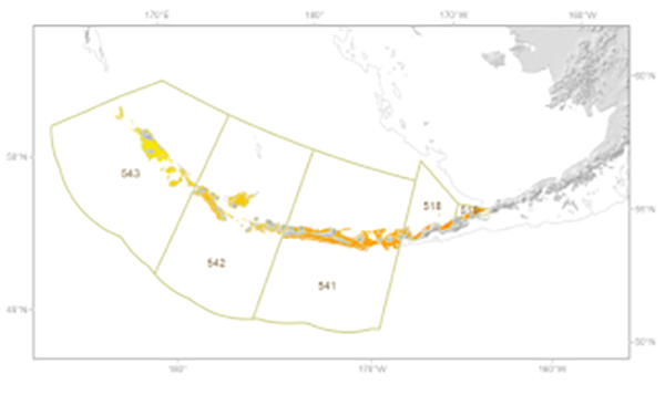
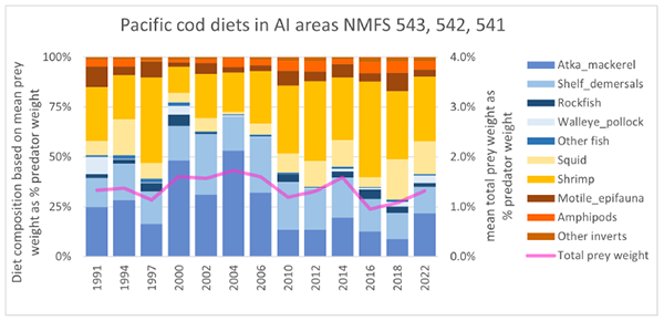
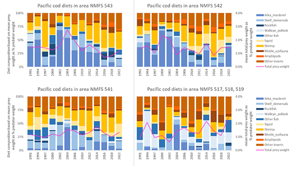
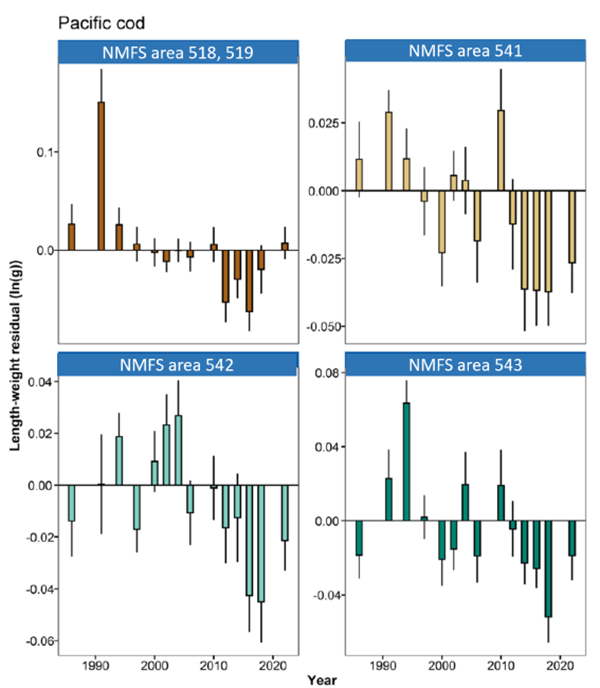
Figure 8: Bottom temperature from mooring Akutan Pass from April 2002 - October 2002 at different depths and satellite-derived daily sea surface temperature for the Aleutian Islands April 2002- October 2002. Contributed by: Ivonne Ortiz1, Stephani Zador2, Ben Laurel3 and Lauren Rogers 2 1Cooperative Institute for Climate, Ocean, and Ecosystem Studies, University of Washington, Seattle, WA2NOAA Fisheries Alaska Fisheries Science Center, Seattle, WA 3NOAA Fisheries Alaska Fisheries Science Center, Hatfield Marine Science Center, Newport, OR Changes in Pacific cod dietThe Alaska Fisheries Science Center Trophic Interactions Lab routinely analyzes stomach samples collected during the biennial bottom trawl survey for the Aleutian Islands. To evaluate changes in prey availability for Pacific cod, we conducted a preliminary analysis of cod stomachs for fish between 30 and 85 cm in length that were collected from survey strata within NMFS areas 541, 542 and 543, as well as east of Samalaga Pass on north side of the eastern Aleutians in areas 518 and 519 (Figure 9). Samples were collected in years 1991, 1994, 1997, 2000, 2002, 2004, 2006, 2010, 2012, 2014, 2016, 2018 and 2022. We found the ratio of fish to invertebrate prey in diets has changed from a majority of fish in the early portion of the time series to a majority of invertebrates in the later portion (Figure 10). Common fish prey include Atka mackerel, and shelf demersals (typically sculpins) while shrimp and squid are the most common invertebrates.We note Atka mackerel has largely not been substituted by other fish prey. The change in the ratio of fish to invertebrates is seen across the Aleutians west of Samalga Pass but is not evident east of the pass (Figure 12). The trend may be partially influenced by the decrease of Atka mackerel, however it also reflect changes in the availability of prey, as there is an overall trend to a decreased amount of prey consumed as a proportio of predator weight. Other apex groundfish predators feeding on a combination of fish and invertebrates have decreased as well, such as skates, Pacific halibut and arrowtooth flounder (Figure 48). A large portion of zooplankton in the system is now consumed by East Kamchatka pink salmon and rockfish. East Kamchatka pink salmon has years of alternating abundance with high abundance in odd years, which had a step increase in 2009 and since then, record abundances have been recorded in 2019, 2021 and 2023. Pacific ocean perch and northern rockfish, both of which have increased in the past several years, also consume primarily zooplankton, have a long lifespan, and in general are little preyed-on by other fish, marine mammals or seabirds, thus locking a large a portion of the energy in the ecosystem. Other factors coinciding with a transition to a higher proportion of invertebrates in cod diets are the higher temperatures since 2013–2014. The also coinciding decline in fish condition since 2013–2014 may also be indicative of several interacting factors, including poor prey quality, low availability of prey, density dependence, and increased metabolic rate (Holsman et al., in press). Contributed by: Ivonne Ortiz1, Kerim Aydin2, Stephani Zador2 1 Cooperative Institute for Climate, Ocean, and Ecosystem Studies, University of Washington, Seattle, WA
Figure 9: NMFS (green outline) and survey (yellow and orange) strata where stomach samples are collected as part of the Aleutian Islands biennial summer bottom trawl survey.
Figure 10: Pacific cod diet in the Aleutian Islands from samples collected NMFS area 541, 542 and 543 as part of the biennial summer bottom trawl survey.
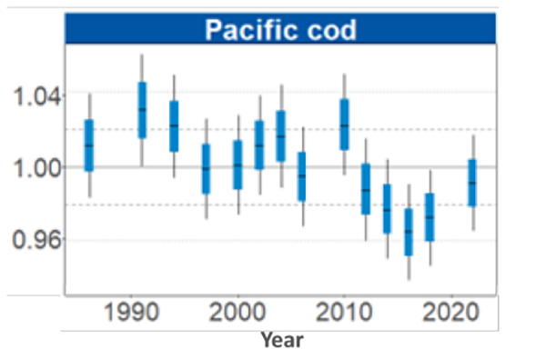
Figure 11: Biomass-weighted residual body condition index across survey years (1984—2022) for Aleutian Islands Pacific cod collected on the National Marine Fisheries Service (NMFS) Alaska Fisheries Science Center (AFSC) Resource Assessment and Conservation Engineering Groundfish Assessment Program (RACE-GAP) standard summer bottom trawl survey. Filled bars denote weighted length-weight residuals using this year’s indicator calculation, error bars denote two standard errors.
Figure 12: Pacific cod diet in the Aleutian Islands by region: NMFS area 541, 542 and 543 and east of Samalga on the northern portion of the eastern Aleutian Islands (NMFS areas 518, 519) and total mean prey weight consumed as a percent of predator’s weight (pink line).
Figure 13: Biomass-weighted residual body condition index across survey years (1984—2022) and by region for Aleutian Islands Pacific cod collected on the National Marine Fisheries Service (NMFS) Alaska Fisheries Science Center (AFSC) Resource Assessment and Conservation Engineering Groundfish Assessment Program (RACE-GAP) standard summer bottom trawl survey. Filled bars denote weighted length-weight residuals using this year’s indicator calculation, error bars denote two standard errors. |

AI Noteworthy 2023
