Mark Wilkins met with colleagues from agencies along the Pacific coast in Seattle on 16 October to discuss whether additional data can be assembled for yelloweye rockfish stock assessments from existing studies. The low abundance of yelloweye rockfish along the Pacific coast of the continental United States has impacted rockfish harvests in the area. This meeting was followed up via teleconference on 5 December. The multi-agency group was unable to direct stock assessment authors to any significant additional information but offered suggestions to enhance data collection from future surveys through the International Pacific Halibut Commission and cooperating agencies.
Mark Wilkins, Michael Martin, Chris Rooper, and Mark Zimmermann attended a 17 November meeting with scientists from the Centers Resource Ecology and Fisheries Management (REFM) Division, Auke Bay Laboratories (ABL), and the Northwest Fisheries Science Center (NWFSC) to discuss how to respond to criticism arising from a Committee of Independent Experts (CIE) review of the Gulf of Alaska rockfish stock assessments.
The points that initiated concern were regarding the practice of applying estimates of mean catch rates from bottom trawl surveys to portions of the survey area that are untrawlable. Several projects were outlined that had potential to address the points raised by the reviewer. We have formed a team within the Groundfish Assessment Program to start working on these concerns and to cooperate with stock assessment scientists to evaluate and work out the problems.
By Mark Wilkins
FISHPAC Project Delivers Bathymetry Data for Nautical Chart Updates
The FISHPAC project is a cooperative effort between RACE Division scientists and other NOAA line offices concerned with nautical charting. A multimission cruise aboard the NOAA ship Fairweather in summer 2006 had both fisheries and hydrographic surveying objectives (see Quarterly Report, July-Sept 2006). The primary purpose of the cruise was to evaluate the utility of acoustic backscatter for fish habitat characterization and to determine the most cost-effective acoustic system for mapping seabed habitats.
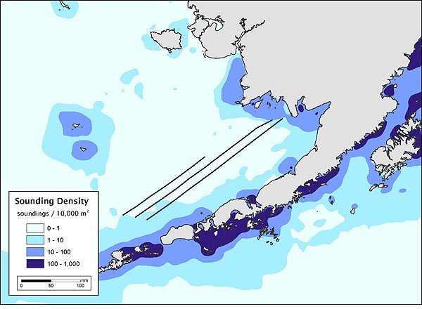
Figure 5. NOAA nautical chart sounding density in the eastern Bering Sea region surveyed during the FISHPAC Bristol Bay Habitat Mapping cruise on the NOAA ship Fairweather. Note sparse soundings data surrounding the three survey tracklines.
Equally important was the objective to provide hydrographic-quality bathymetry data to the NOAA Pacific Hydrographic Branch (PHB) for updating nautical charts in areas with outdated or nonexistent information (Fig. 5 above). The role played by the NOAA Corps Benthic Mapping Specialist was integral to this effort. LT(jg) Jay Lomnicky is jointly assigned to the RACE Habitat Research Team and the PHB, in direct support of NOAAs Matrix Management Initiative. This position is intended to coordinate efforts between NMFS and the Office of Coast Survey and is the first such cross-over billet for a hydrographic officer. The overall responsibility is to apply hydrographic and mapping skills in support of fisheries research while, at the same time, assuring that data acquisition and processing meet hydrographic standards.
During the Bristol Bay Habitat Mapping cruise on the Fairweather, over 2,000 nautical miles were surveyed with multiple acoustic systems during three passes over pre-planned transects
(see cruise report, .pdf 527kb). From these data approximately 920 nmi of unique trackline data were acquired using the Fairweather s two multibeam echosounders. These bathymetry data have been processed by LT(jg) Lomnicky and ships personnel, and have been formally submitted to PHB for nautical chart updates. Backscatter data from these (and other) systems are currently being processed at the NOAA University of New Hampshire Joint Hydrographic Center. The final product from this effort will be fully corrected backscatter data that are applicable to the fisheries research objectives.