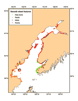
Smooth sheet features of Cook Inlet. Click map to enlarge.
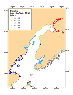
Shoreline features of Cook Inlet. Click map to enlarge.
Smooth Sheet Features of Cook Inlet
A total of 12,000 features such as rocky reefs, kelp beds, rocks, and islets were digitized from the smooth sheets and added to the original files from NGDC, resulting in a total of 18,000 features.
Almost 10,000 of these points indicated the edge of rocky reefs, covering much of the shore in Kamishak Bay, the southern shore of Kachemak Bay, and near Chisik Island, but reefs were rare north of there.
More than 7,000 rocks and more than 800 islets were found along most of the Cook Inlet shore. There were less than 300 kelp beds, almost all of which occurred in outer Kachemak Bay.
Altogether there were almost 18,000 rocks or rock ally features such as rocky reefs, kelp beds, and islets, which were added to the sediment data set.
Shoreline of Cook Inlet
A total of 95,000 individual shoreline points were also digitized, describing 2,418.3 km of mainland shoreline and 528.9 km of island shoreline from 507 individual islands, providing the most detailed shoreline of Cook Inlet.
The shoreline is defined on the smooth sheets as MHW (Mean High Water), the same vertical tidal datum as the bathymetry, which typically ranges only as shallow as MLLW (Mean Lower Low Water), defined as zero meters depth.
The MHW shoreline was highest in the northern end of Cook Inlet, ranging up to -9.2 m in Turnagain Arm, and -9.1 m in Knik Arm, and lowest at Augustine Island and Kamishak Bay (-4.4 to -3.4 m, respectively).
By adding the digitized shoreline to the digitized bathymetry, a complete bathymetry map for Cook Inlet was assembled without the typical gaps between the shallowest soundings and the shoreline. Thus, researchers were able to determine that at high tide (MHW) the total volume of the inlet is 1,024.1 km3 and the total surface area is 20,540 km2. When the tide drops from MHW to MLLW, the Inlet loses 99.7 km3 of water, or 9.7% of its volume, and exposes 1,616 km2 of seabed, or 7.9% of its surface area.
Conclusion
While the Alaska Fisheries Science Center has been conducting marine research for decades in Alaskan waters, a lot of basic information about the seafloor, such as depth, is generally not known beyond what is depicted on small scale (1:100,000) NOS Navigational Charts. Therefore, AFSC scientists have been creating more detailed bathymetry and sediment maps in order to provide a better understanding of how studied animals interact with their environment. This information is being used by NOAA’s Deep Sea Coral Research and Technology Program to predict the presence/absence and abundance of corals and sponges. More information on these studies is featured in the AFSC research report Determining the Distributions of Deep-sea Corals and Sponges Throughout Alaska.
Scientists who conduct AFSC stock assessment bottom trawl surveys are also using the information to delimit areas that cannot be sampled effectively with bottom trawls. The results from the AFSC mapping project may result in an alternative survey method such as underwater cameras or acoustics to assess the abundance of fish in untrawlable areas.
An inter-agency collaboration, the Gulf of Alaska Integrated Ecosystem Research Program (GOA-IERP), sponsored by the North Pacific Research Board, is using the detailed bathymetry and sediment information to predict the preferred settlement habitat juveniles of five important groundfish species. Results from GOA-IERP will be used towards developing a better understanding of the ecosystem processes that regulate stock recruitment.
The Alaska Regional Office will investigate use of the bathymetry and sediment information to oversee sustainable fisheries, conduct Essential Fish Habitat (EFH) reviews, and manage protected species. The Bureau of Ocean Energy Management may use the information for preparing National Environmental Policy Act (NEPA), Essential Fish Habitat (EFH), and Endangered Species Act (ESA) documents for the possibility of a federal lease sale in lower Cook Inlet.