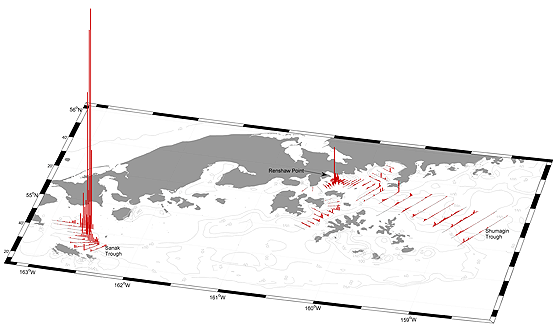
Figure 1. Acoustic backscattering (sA) attributed to walleye pollock (vertical lines) along transects during the February 2012 acoustic-trawl surveys of the Shumagin Islands and Sanak Trough in the Gulf of Alaska. The largest value shown in this figure represents 36,700 sA.
Scientists from the Midwater Assessment and Conservation Engineering (MACE) Program conducted winter acoustic-trawl surveys aboard the NOAA ship Oscar Dyson in the Gulf of Alaska (GOA) and southeastern Bering Sea. The surveys provide data on the abundance, distribution, and biological composition of prespawning walleye pollock, Theragra chalcogramma. Areas surveyed between 15 and 20 February 2012 included Sanak Trough and the Shumagin Islands (Shumagin Trough, Stepovak Bay, Renshaw Point, Unga Strait, and West Nagai Strait). The area in the vicinity of Bogoslof Island in the southeastern Bering Sea was surveyed between 7 and 15 March. Areas surveyed between 17 and 26 March were the shelfbreak east of Chirikof Island and the Shelikof Strait area. All surveys were conducted 24 hours per day.
In Sanak Trough, preliminary survey results indicated that the 2012 biomass estimate was similar to recent surveys (2008-10). Most walleye pollock were located in the northern part of the survey area within the trough proper (Fig. 1), and the size composition was unimodal, with most fish between 40 and 70 cm fork length (FL). Unlike all previous surveys, which had high percentages of spawning and spent females, the 2012 survey reflected lower percentages although survey timing was similar to previous years. The preliminary 2012 walleye pollock abundance in the Shumagin Islands area was the lowest in survey history and was less than one-quarter of the 2007 estimate, which was a 5-year high. Light near-bottom adult walleye pollock densities were detected off Renshaw Point (Fig. 1), where until 2007 the highest quantities of adults had historically been detected. Light on-bottom echosign was detected in Shumagin Trough. Very little echosign attributed to walleye pollock was detected elsewhere in the Shumagin Islands. The length distribution of walleye pollock in the Shumagin Islands area consisted primarily of adult fish between 40 and 70 cm fork length
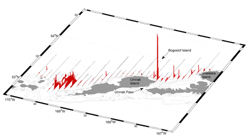
Figure 2. Acoustic backscatter (sA) attributed to walleye pollock (vertical lines) along tracklines during the March 2012 acoustic-trawl survey of walleye pollock in the southeast Aleutian Basin near Bogoslof Island. The largest value shown in this figure represents 19,300 sA.
Figure 3. Acoustic backscattering (sA) attributed to walleye pollock (vertical lines) along transects during the March 2012 acoustic-trawl surveys of Shelikof Strait and along the Gulf of Alaska shelfbreak from Barnabas Trough to Chirikof Island. The largest value shown in this figure represents 51,500 sA.
The preliminary walleye pollock abundance estimate in the southeastern Aleutian Basin near Bogoslof Island was the lowest in survey history. Pollock were observed northeast of Umnak Island and in the Samalga Pass region with the densest aggregations off Umnak (Fig. 2). The size composition ranged from 41 to 68 cm FL, with a dominant mode centered at 50 cm in the Umnak Island region and 60 cm in the Samalga Pass region. Preliminary analysis of maturity stages indicated that the majority of female pollock were prespawning in both the Samalga and Umnak regions, indicating that the survey timing was consistent with historical efforts.
The preliminary walleye pollock biomass estimate in Shelikof Strait was about 75% of the 2010 estimate but higher than those of 2006-09, and, as in 2010, the highest fish densities were observed along the west side of the strait proper between Cape Kekurnoi and Cape Kuliak (Fig. 3). Densities were relatively light on the Kodiak side of the strait and south of the strait proper. Most pollock catches consisted of a mixture of age-2 and older adult fish, with older fish dominating in the deepest part of the strait and the reverse true elsewhere. The 2012 pollock biomass estimate along the GOA shelf break in the vicinity of Chirikof Island was the highest observed since 2008. As is typical for this survey, only adult fish were observed. Preliminary analysis of maturity stages revealed that the majority of female pollock were prespawning in both the Shelikof Strait and along the Chirikof shelf break, indicating that the survey timing was consistent with historical efforts.