Long-term Satellite Tags on Ribbon Seals Begin to Pay Off
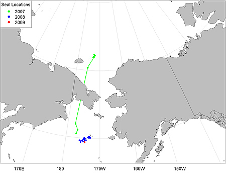
Figure 8. Multiyear movements of a ribbon seal tagged by the Polar Ecosystem's Program in May 2007.
In February 2009, the Polar Ecosystems Program (PEP) received data transmitted from a satellite tag deployed in May 2007 on a ribbon seal in the central Bering Sea. This represents a deployment length of more than 620 days. We believe this may be the longest deployment of a satellite tag on a marine mammal.
This particular ribbon seal traveled into the eastern Siberian Sea in summer 2007 and then returned to the Bering Sea in spring 2008 (Fig. 8). The latest location was along the sea-ice edge, 135 km southwest of St. Matthew Island.
The satellite tag was designed and developed in cooperation with Wildlife Computers (Redmond, Washington) and is attached to the rear flipper of the seal. The tag measures 3 inches x 0.75 inches x 0.33 inches and is glued to a cattle ear tag for secure attachment to the inter-digital webbing of the rear flipper. Because the tags are attached to the rear flippers, they only transmit to the ARGOS satellites when the animal is out of the water, resting on sea ice.
We are especially interested in the behavior of ribbon seals during the pupping, breeding, and molting season when they are often found within the marginal sea-ice zone. Therefore, we have programmed the tags to come on for 4 hours every 4 days from 1 April to 30 June and twice a month during the rest of the year.
The 4-hour period corresponds with the period of maximum satellite coverage in the Bering Sea. This increases the quality of determined location and bandwidth of data transmission.
In addition to providing locations, the tags also record and transmit timelines of haul-out behavior. This provides us with information on how the seals are using sea ice during this critical time and also helps us correct aerial surveys to account for seals that are in the water.
Tags were also deployed on other ribbon seals and spotted seals during spring 2007 and 2008. We hope to receive transmissions from additional animals as we move into spring 2009.
We will be conducting additional captures off the NOAA ship McArthur II from mid-May to mid-June 2009 and will be deploying a new version of these tags with twice the battery life.