Meteorological observations and their summarization in climatological studies are critical data for fisheries oceanographers and ecologists. Solar radiation, temperatures, precipitation, and their variations drive ocean currents, circulation, and photosynthetic processes which in turn influence the fluctuations of biological populations important to fisheries. Consequently, daily weather observations and the maintenance of these records are important to NOAA's mission and its several components: the National Weather Service (NWS), the National Marine Fisheries Service (NMFS), and National Ocean Service (NOS).
Daily weather observations at the Auke Bay Marine Station were initiated in February 1963 as part of the National Weather Service Cooperative Observer Program. The observations include the daily maximum and minimum air temperature, daily precipitation, daily snowfall, and snow on the ground. Sea surface temperatures (SST) have been included since 1975. Daily observations are taken at about 16:30 hours.
The calendar year 2008 was notable for being a wet, cold year. This was particularly evident in the SST observed at the Auke Bay Marine Station float.
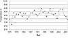
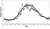
The annual average SST since 1975 has been 8.17°C, the 2008 average SST was 7.38°C, the second lowest annual SST in the time series (Fig. 1). With few exceptions, the daily SST remained well below average throughout 2008 (Fig. 2). July through mid-September was unusually cold. Although it is too early to see the results of such a year on our fisheries, these cold winter-spring-summers have been associated with poor recruitment to salmon, halibut, sablefish, and rockfish stocks in Southeast Alaska.
The year 2008 was a typical wet year, having 69.11 inches (175.54 cm) of precipitation compared to the average of 60.64 inches (154.03 cm). Maximum recorded precipitation was 84.80 inches (215.39 cm) in 1991. The nearly continuous cloud cover, especially through the summer, left the impression of an unusually wet year. This was especially so for gardeners and berry pickers, because there was a poor set of most local berries, and raspberries went moldy before ripening.
The 2007-08 snowfall was well above average121.3 inches (308.2 cm) compared to the average of 87.6 inches (189.7 cm). December 2008 had 28.6 inches (72.6 cm) snowfall, not greatly different from the average 21.0 inches (53.3 cm). However this snow fall did not penetrate through the tree cover, thereby leaving the ground uncovered and exposed to deep freezing during the middle of the month.
This does not bode well for those animals (i.e., toads and some insects) and plants that depend on snow cover insulation during their winter hibernation. This also contributes to low stream flows during the winter when salmon eggs and fry are still in the stream bed gravel.
AIR TEMPERATURES:
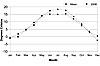
Monthly average air temperature followed much the same pattern as the SST. The monthly mean high temperature (Fig. 3) was below average from May through October. This was probably due to the near continuous cloud cover excluding incoming solar radiation. The monthly mean low temperatures were not significantly different for the long-term averages, while the mid-range temperatures were slightly below normal through the summer and early fall.
UPDATE:
January 2009 was unusual by having alternating very cold and record warm periods along with record rains and record snows. With over 72.4 inches of snow and 9.65 inches of precipitation, January 2009 had the highest recorded January snowfall and precipitation at Auke Bay. The previous maximum snowfall for January was 71 inches in 1982. Previous maximum precipitation was 9.38 inches in 1985.
The 2008-09 seasonal snowfall has been the fifth highest in our Auke Bay records, with 147 inches of snow. Auke Bay sea surface temperatures remained near 1°C below average through March. The sea surface temperatures in the Northeast Pacific, Gulf of Alaska, and Bering Sea are also 1° 2°C below average.