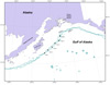
In March, the RACE Divisions Groundfish Assessment Program conducted its second annual Mesopelagic Survey. The mesopelagic zone, which ranges from 200 to 1,000 m, is home to many small, deepwater fish species (e.g., lanternfish and deep-water smelts) as well as many midwater invertebrates, which form a forage base for a variety of demersal and pelagic fish species, marine mammals, and seabirds. The primary objective of this survey is to establish an index of production and species diversity in the mesopelagic zone along the shelf break in the area between Prince William Sound and southern Kodiak Island.
The 2008 Mesopelagic Survey was conducted 1218 March aboard the NOAA ship Miller Freeman. During the survey a total of six stations, spaced approximately 40 nautical miles (nmi) apart, were sampled along the shelf break between Kodiak and Middleton Islands in the Gulf of Alaska (Fig. 1).
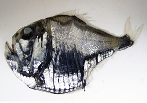
Figure 2. This hatchetfish is one of the mesopelagic fishes encountered in the 2008 Mesopelagic Survey in the Gulf of Alaska.
The gear used to sample these stations was the large, midwater Aleutian wing trawl, commonly used in RACE midwater assessments, with a ½-inch stretched-mesh liner in the codend. Each station was sampled with a daytime and a nighttime series of tows, each series consisting of three tows at 250-, 500-, and 1,000-m depths. The trawl was towed at 3 knots for 30 minutes once it had reached its target depth.
After each catch was brought aboard, all organisms were sorted to the lowest taxonomic group possible, then counted and weighed (Fig. 2). The most common species were frequently subsampled. Length frequencies, stomach samples, and individual voucher specimens were then collected. Favorable weather provided ideal survey conditions and made for a successful cruise, enabling us to complete 33 out of 36 possible tows.