FISHPAC Cruise Investigates Fish Habitat and Updates Nautical Charts
in the Eastern Bering Sea
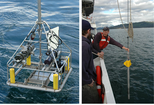
Figure 8. Groundtruthing devices used during the FISHPAC 2009 cruise include the SEABOSS sediment grab/camera system (left), used to collect physical and biological samples from the seabed, and the FFCPT sediment profiler (right) which collects sound velocity data as it free falls in the water column and then takes geotechnical measurements as it imbeds itself into the bottom.
Scientists from the RACE Habitat Research Group (HRG) assembled in Dutch Harbor for a multi-mission habitat cruise on the NOAA ship Fairweather. The FISHPAC project is an ongoing effort to evaluate the utility of acoustic backscatter for characterizing essential fish habitat (EFH) in the eastern Bering Sea (EBS) and to compare the performance of various acoustic systems for that purpose. This approach is based on prior HRG research indicating the distribution and abundance of many groundfish species is related to surficial sediment properties.
Direct sampling of sediments with grabs and coring devices is, however, impractical over areas as large as the EBS shelf. Acoustic tools, on the other hand, are suitable for large-scale surveying and show great promise as a substitute for the more traditional samplers, but they have not been proven for EFH purposes.
In keeping with NOAA's Integrated Ocean and Coastal Mapping Initiative, the HRG team is working closely with other branches of NOAA to acquire bathymetric data that meet hydrographic standards and can be used to update nautical charts in areas with outdated or non-existent information. In 2009, the project also had the good fortune to work with a very capable and energetic high school science teacher participating in the NOAA Teacher At Sea program.
The 2009 survey area consisted of six 110-140 nautical mile tracklines across the EBS shelf at depths ranging from 20 to 160 m. These survey lines were chosen to pass directly over 31 RACE bottom-trawl-survey stations at which a wide range of fish and invertebrate abundances has been observed.
Nine additional stations were added at intermediate locations along lines 7 and 8, for a grand total of 40 stations. Over the period 26 July to 8 August, each line was navigated once with continuous shipboard operations. On every pass, backscatter and bathymetry data were collected using the ship's two multibeam sonars (Reson models 8111-ER operating at 100 kHz and 8160 at 50 kHz) with operator settings tuned for backscatter data.
Two sediment grabs and multiple digital still photos were collected at each station using the Seabed Observation and Sampling System (SEABOSS) (Fig. 8 above). One of these grabs will be used for a laboratory analysis of sediment properties and the other will be processed to characterize invertebrate organisms living in the substrate.
Actual sampling locations were determined with an ultra-short baseline (USBL) positioning system that was interfaced with the ship's navigational instruments. Geophysical properties of the seabed, as well as sound velocities in the water column, were measured at each station using a Brooke Ocean Technology free-fall cone penetrometer (FFCPT) (Fig. 8). Conductivity-temperature-depth casts were also performed to provide additional sound-velocity data and ensure high-quality hydrographic products.
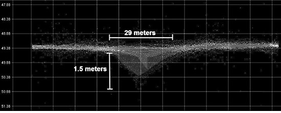
Three additional activities were undertaken using available ship time. During the cruise, a feature resembling a bowl or depression in the seafloor was detected between the standard survey lines. One of the Fairweather survey launches was deployed and investigated the area with a very high-resolution multibeam system (Reson model 8125 operating at 455 kHz).
Figure 9. Two-dimensional representation of an unknown bowl-shaped feature detected in Bristol Bay during the 2009 FISHPAC cruise.
A preliminary review of the data revealed a depression of unknown origin, measuring approximately 29 m in diameter and 1.5 m deep (Fig. 9 above). A more comprehensive look at this feature will be undertaken in the future.
In addition to the planned survey lines, the Fairweather and the FISHPAC team acquired bathymetry and backscatter data during two passes along a short transect near Dutch Harbor. These hydrographic-quality data will be compared with data collected a few weeks earlier by the NOAA ship Oscar Dyson using a multibeam sonar (Kongsberg ME70) configured to survey the water column rather than the seabed.
At the end of the cruise, performance characteristics of the USBL system were investigated during the transit to Dutch Harbor. The USBL transceiver that communicates with transmitters on the various towed objects had previously been mounted on a pole that was temporarily attached to the Fairweather.
In response to a structural failure of the mounting pole during the 2008 FISHPAC cruise, the USBL transceiver on the Fairweather was moved to the hull of the vessel during the winter repair period. Some significant deficiencies were noted during the investigation and additional testing of the hull-mounted transceiver is needed.