During June and July 2008 the RACE Division conducted the biennial eastern Bering Sea upper continental slope groundfish survey. The 2008 survey marked the third effort that extended the time series comprising previous efforts in 2002 and 2004 (2006 not attempted). We completed 200 successful tows at depths of 200-1,200 m along the continental slope of the eastern Bering Sea from Akutan Island toward the northwest to the international boundary. The objectives of the survey are to describe the status and trends of groundfish and invertebrate resources by current composition, spatial and depth distribution, and relative abundance of groundfish and invertebrate resources, and to collect biological data from a variety of commercially and ecologically important species. In addition we collect environmental and ocean condition measurements such as bottom depth, surface and bottom water temperatures, light levels, and sea states to relate long-term changes in fish and invertebrate distribution with changes in oceanographic conditions.
By Gerald Hoff
Untrawlable Grounds Research in the Eastern Aleutian Islands
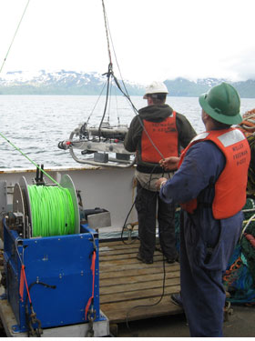
Figure 4. A towed video camera system aboard the NOAA ship Miller Freeman is deployed during a study of untrawlable grounds in the eastern Aleutian Islands. Photo by Frank Shaw.
Biennial bottom trawl surveys conducted in the Gulf of Alaska (GOA) and Aleutian Islands (AI) by the RACE Division are a primary method of monitoring the status and trends of commercial groundfish abundance. These stock assessment surveys follow a stratified random sampling design. However, trawling is not possible in areas that are too rough, hard, or steep. Thus, a bias persists when using bottom trawl surveys to estimate groundfish biomass when the unknown (but presumed large) amount of the continental shelf is not accounted for with our standard survey bottom trawl gear.
In July 2008 we completed our second cruise using acoustics and video groundtruthing to develop methods for classifying trawlable and untrawlable grounds in the GOA and AI trawl survey areas. All operations were conducted aboard the NOAA ship Miller Freeman. Seabed acoustic backscattering was collected continuously along a series of transects with a Simrad ER60 scientific echosounding system incorporating four centerboard-mounted transducers (18, 38, 120, and 200 kHz). A towed camera and winch system with artificial lighting (Fig. 4) was used for video validation of acoustic data.
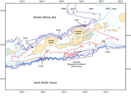
Only about half of the planned work was completed because the ship suffered mechanical problems and was forced to return to Dutch Harbor well before the completion of the cruise. Nevertheless, about 1,000 km of acoustic transect data (about 14 GB) were collected, along with over 10 hours of seafloor video and five CTD casts (Fig. 5). Vessel motion data, which is critical for correcting the acoustic returns, were successfully collected throughout the cruise. Seafloor substrate types ranged from soft mud to gravel to boulders, providing valuable contrast for distinguishing different acoustic signatures. We were able to locate limited areas of sponge and a skate nursery on a GOA Essential Fish Habitat closure area that is proposed as a potential Habitat Area of Particular Concern site. A new Atka mackerel (Pleurogrammus monopterygius) nursery area was also discovered.
We thank John Harms of the Northwest Fisheries Science Center and Matt Barnhart and Jim Benante of the Pacific States Marine Fisheries Commission for the use of their camera system and for so graciously sharing their expertise with us. Scott McEntire (AFSC) provided technical expertise and equipment in preparation for this cruise.
By Mark Zimmermann
Figure 5. Transects completed during cruise MF0807. Numbers indicate approximate locations of video camera drops. Black dots indicate conductivity-temeperature-depth (CTD) casts.