Gulf of Alaska Groundfish Trawl Assessment Survey Completed
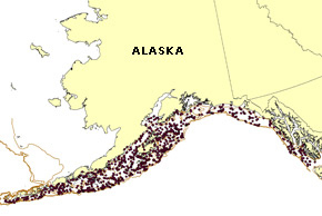
Figure 5. Map showing bottom trawl tows (filled circles) completed during the 2007 Gulf of Alaska groundfish survey.
The fifth in the series of biennial bottom trawl surveys of Gulf of Alaska (GOA) groundfish resources, which began 25 May, was completed on 7 August 2007, covering the continental shelf and slope between the Islands of the Four Mountains (170°W long.) and Dixon Entrance (U.S.-Canada border in Southeast Alaska) out to the 1,000-m depth contour.
The survey was conducted aboard three chartered commercial trawlers, the FV Gladiator, the FV Sea Storm, and the FV Vesteraalen. A total of 820 tows were successfully completed, ranging in depth from 16 to 903 m (Fig. 5).
The primary focus of the biennial groundfish surveys is to build a standardized time series of data designed to assess, describe, and monitor the distribution, abundance, and biological condition of various GOA groundfish stocks. Specific objectives of the 2007 survey, as in others preceding it, were to:
Define the distribution and relative abundance of the principal groundfish and invertebrate species inhabiting the continental shelf and slope of the GOA.
Collect data to define various biological characteristics of major groundfish species, such as age, sex, size, growth rates, length-weight relationships, and feeding habits.
Collect integrated fishing performance, net configuration, and position data for all trawl hauls with which to derive precise effort estimates.
Collect environmental data such as surface-to-bottom water column temperatures.
Collect biological specimens and data requested by scientists from the AFSC or other cooperating research groups.
Over the entire survey area, the most abundant species in 2007 were, in descending order, arrowtooth flounder, Pacific ocean perch (POP), giant grenadier, Pacific halibut, walleye pollock, flathead sole, Pacific cod, and northern rockfish. Abundance has apparently decreased for most of these species since 2005; declines ranged from 10% for POP to 17% for pollock, giant grenadier, and halibut; to 24% for cod; and 37% for northern rockfish.
The arrowtooth flounder abundance held steady since 2005. Of these major species, only flathead sole exhibited an apparent increase in estimated abundance of 31%. Other notable changes were dramatic increases in the apparent abundance of Pacific hake (69%) and spiny dogfish (238%).
Arrowtooth flounder and POP were the two most abundant species in both the eastern and central Gulf of Alaska. While arrowtooth were also the most abundant species in the western GOA, POP fell to third most abundant species in that area, surpassed by giant grenadier. Estimates of abundance, distribution, and size composition from the survey results have been provided to stock assessment analysts for updates to the annual Stock Assessment and Fishery Evaluation (SAFE) Report of the North Pacific Fishery Management Councils (NPFMC) GOA Plan Team.
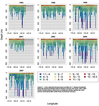
Water temperatures observed during the 2007 survey exhibited a much different pattern than previous GOA surveys, as cooler water infiltrated shallower depths, often with warmer water below. Water temperatures from GOA surveys, adjusted to remove the effect of date of collection through the use of a general linear model, are shown in Figure 6.
The very warm near-surface temperatures that were observed in 2003 and 2005 were largely absent in 2007. In all years prior to 2007, water temperatures at depths greater than 400 m have generally been cooler than 4°C. In 2007, water warmer than 4°C extended to almost 600 m most of the time. The pattern of water temperatures in 2007 more closely resembles the pattern in 1993 than any other year, although the intrusion of colder water into shallower depths is much more pronounced in 2007.