Tests of New Sampling Technique to Track Harbor Seal Populations in Alaska Fjords
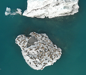
Figure 3. Unusually dense aggregation of harbor seals on grounded glacial ice in Bering Lake, southcentral Alaska. Photo by John Jansen.
Researchers from the Polar Ecosystems Program (PEP) are testing a new aerial survey technique for tracking populations of harbor seals that haul out in glacial fjords. Tidewater glacial fjords in Alaska attract the largest numbers of harbor seals in the state, if not the world, and because these seals (up to 5,500) are scattered across enormous fields of floating ice that shift with ocean and wind currents, they are particularly difficult to count.
Traditional methods for estimating abundance by visual techniques or by taking oblique photographs have yielded highly variable counts or counts where the error was unknown. More recent techniques have used high-altitude (3,000-4,000 ft) photogrammetry of the entire seal haul out. However, these surveys require exceptional visibility and weather (not typical of survey areas), so this method has sometimes resulted in photographs of varying quality and less-than-certain seal identification. These surveys also require a considerable time investment in post-processing and analysis (e.g., digitizing negatives and distinguishing seals), which, when combined with the expense of outsourcing the photogrammetry, makes this method time-consuming and costly.
Thus, the PEP is testing a new aerial sampling method, which captures higher quality imagery of seals at lower altitudes (1,000 ft), along line transects, using a down-looking, high-resolution digital single-lens reflex (SLR) camera. The images are georeferenced and analyzed using conventional GIS software to map seal locations in non-overlapping images that represent about 40% of the ice field.
This technique was developed to test hypotheses regarding seal disturbance in Disenchantment Bay, but it holds promise as a more timely and cost-effective method for estimating total abundance using spatial statistical models currently being developed. The high quality imagery also allows for detailed analyses of individual seals (e.g., discriminating mother-pup pairs and population structure) and ice characteristics.
As part of the PEPs annual harbor seal surveys, which rotate through five regions of the species range in Alaska (see article above), biologists photo-sampled ice-hauling seals in five tidewater glacial fjords: Icy and Disenchantment Bays in the Gulf of Alaska, and Tracy Arm, Endicott Arm, and LeConte Bay in Southeast Alaska.
The line transects were flown by NOAA Corp pilots Steve Kroening and Jason Seifert aboard the NOAA Marine and Aviation Operations AC-500 Shrike (N47RF). A mounting platform constructed specifically for the surveys allowed the camera to be quickly installed and pointed vertically through the planes belly port. Flights were timed daily to overlap with the peak abundance of seals, which radio-telemetry studies suggest occurs between 1300 and 1600 hours. Surveys were conducted from 5 to 21 August 2007 to coincide with the seals annual molt. The single NMML observer was based first in Yakutat (for 10 days) and then in Juneau.
Visibility was generally favorable in Yakutat and just manageable in Juneau, allowing the team to complete three replicate surveys of each glacial site. Surveys based in Yakutat included two unique sites (Malaspina and Bering Lakes) where seals haul out in fresh water at high densities on pieces of grounded (not tide or wind-forced) glacial ice (Fig. 3), a situation that doesnt present the same logistical problems as moving ice fields with scattered seals.
This year, as in past surveys, tidewater glacial sites attracted several hundreds to thousands of seals, except for Endicott Arm, which averaged less than 10 seals. The unusually low number of seals in Endicott Arm was likely due to the relatively small amount of ice that had been calved from the glacier at the head of the arm.