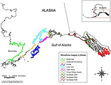
Figure 1. Map showing Alaska coastline inventoried using the ShoreZone classification system. (click map to enlarge)
Aerial imagery and mapping are key to coastal habitat assessments. With more than 50,000 km of shoreline in Alaska, it is physically impossible to assess all of it in a workable period of time. The first task is to establish a baseline that maps and characterizes the coastline; several agencies have committed to accomplishing this by using the ShoreZone classification system. Through partnerships with federal, state, and nonprofit organizations, about 28,000 km (or nearly half of Alaskas coastline) have been inventoried using the ShoreZone classification system (Fig. 1). The shoreline is photographed continuously on a minus tide, and the geo-referenced imagery is analyzed later for physical geomorphology and for biological resource characteristics (e.g., kelp beds, eelgrass beds).
The project combines several methods: 1) collection of aerial videographic and still photography, 2) coastal resource mapping, 3) ground work at a limited number of shore stations, and 4) a Web-based Arc IMS database that is available to managers and the public. ShoreZone has proven to be a valuable management tool for oil spill contingency planning, permitting for coastal development, mariculture, and nearshore research, and can be used in the future to track climate change impacts on coastal nearshore resources. The Alaska Regional Office and ABL have been collaborating to complete the mapping of southeastern Alaska.
Southeastern Alaska represents a challenge for habitat research, possessing over half of Alaskas coastline with its unique combination of fjords, bays, inlets, estuaries, and at least 1,000 named islands. Between 2004 and 2005, over 6,000 km were mapped in the northern regions of southeastern Alaska from Icy Bay to Sitka Sound and the inside waters from Skagway to Juneau, Gustavus, and Tenakee Inlet.
Fiscal Year 2006 marks a pivotal year, with more than 7,000 km imaged in southern southeastern Alaska, focusing on the Ketchikan, Craig, and Prince of Wales areas. With more than 40% of southeastern Alaska surveyed and with continued funding, completion of southeastern Alaska survey work will be a reality in the future. To view our progress, visit the following Web sites
at http://www.fakr.noaa.gov/maps/szintro.htm or http://www.coastalaska.net/.