Bering Sea Integrated Ecosystem Research Program (BSIERP) Spring Cruise
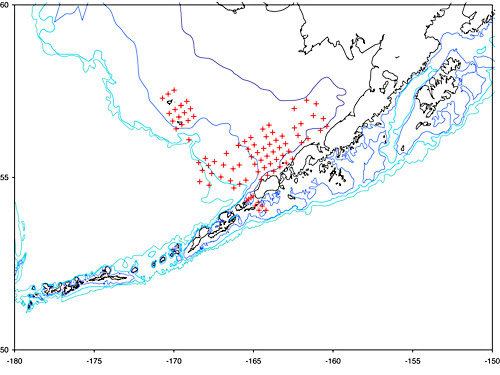
Figure 10. Map of eastern Bering Sea and Aleutian Islands showing station locations of the BSIERP May 2009 spring cruise.
The Bering Sea Integrated Ecosystem Research Program (BSIERP) spring cruise was conducted 7-20 May aboard the NOAA ship Oscar Dyson in the Bering Sea to examine the interactions among climate, weather, and recruitment of fishes in the eastern Bering Sea.
Ichthyoplankton and zooplankton sampling was conducted in the waters along the eastern Aleutian Islands chain, the Alaska Peninsula, and the Pribilof Islands (Fig. 10 above) in order to examine horizontal and vertical distribution of larval walleye pollock, Pacific cod, and arrowtooth flounder as well as the abundance and distribution of their plankton prey, and to perform genetic discrimination of Atheresthes spp. larvae at sea using molecular techniques (see previous article by Mike Canino).
The cruise represents collaboration between NPRB/BSIERP and NOAA's North Pacific Climate Regimes and Ecosystem Productivity program. Eighty-one stations were sampled for ichthyo- and zooplankton abundance using a bongo net array and a neuston net (505 µm mesh). The contents of one of each of the bongo nets and the neuston net were immediately preserved in sodium borate-buffered formalin to be sorted and identified at a later date. The contents of the remaining 60-cm bongo net were sorted live for fish larvae.
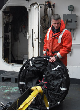
Figure 11. Kenric Osgood deploying a drifter aboard the Oscar Dyson during the BSERP spring cruise.
Sampling occurred along the slope between Bering and Pribilof Canyons, and approximately two dozen Atheresthes spp. larvae were collected. Catches of walleye pollock eggs in the Pribilof Island vicinity were high, particularly in the surface neuston tows. Catches of walleye pollock larvae, however, were relatively low compared to other years.
Water temperatures were very cold (<1°C), which may have influenced the abundance of larvae, either by affecting the location or timing of spawning by adults. In total, only 25 walleye pollock larvae were collected at 15 stations around the islands, and no Pacific cod were encountered. Two stations in the Pribilof Islands were sampled for vertical distribution of fish eggs and larvae with the multiple opening/closing net and environmental sensing system (MOCNESS) (505 µm mesh).
Sea ice was present over the middle shelf during the cruise and is further evidence of the very cold conditions over the middle and outer shelves this past May. Plankton sampling along the Alaska Peninsula revealed very few larvae of any fish species, and water temperatures were also low (-1.5°C). Only 25 walleye pollock and 2 cod larvae were collected at 46 stations along the Alaska Peninsula. Typically catches of larvae are 1-2 orders of magnitudes higher (10100X) in these geographic locations.
Sampling also occurred across Unimak Pass and over Bering Canyon. Three satellite-tracked drifters were released during this cruise (Fig. 11), the first over the slope, the second between St. George and St. Paul Islands, and the third along the Alaska Peninsula. Drifter tracks can be viewed on the web site of our collaborators at NOAA's Pacific Marine Environmental Laboratory (www.ecofoci.noaa.gov/drifters/efoci_drifterData.shtml).
A cruise in July on the research vessel Knorr will use the drifter data to locate the fish contained in the spring patches and conduct additional sampling for the NPRB/BSIERP.
Of the 47 Atheresthes spp. larvae collected, we were able to genetically identify 41 individuals to species while at sea. Catches at the northern stations (between the Bering and Pribilof Canyons and in the Pribilof Islands) tended to have more Kamchatka flounder than Arrowtooth flounder, while catches at the southern stations (Unimak Pass and Bering Canyon) tended to have more Arrowtooth than Kamchatka flounder.