Testing a Ship-Based Unmanned Aerial Aircraft System (UAS) for Surveying the Bering Sea Pack Ice
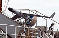
Figure 5. ScanEagle unmanned aerial aircraft system (UAS) ready for launch with propeller guard in place.
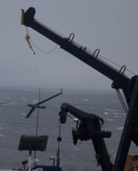
Figure 6. The SkyHook recovery system is composed of a line suspended between the ship’s crane and a lower boom.
Figure 7. ScanEagle UAS about to capture the SkyHook line for recovery.
The Polar Ecosystems Program (PEP) conducted tests of an unmanned aerial aircraft system (UAS) to determine its effectiveness for surveying subarctic pack ice for ice seals. The tests were conducted as part of a research cruise in the eastern Bering Sea this spring, 13 May–11 June 2009, aboard the NOAA ship McArthur II.
Over the next several years, NOAA intends to gain the capability to incorporate UASs as a tool for collecting data relevant to its science goals. Before broad-scale surveys using UASs can be conducted, however, platforms and instruments must be evaluated to ensure that mission goals can be effectively met. The PEP usually conducts aerial surveys for ice seals using helicopters based from a U.S. Coast Guard ice breaker. NOAA’s UAS program identified the Arctic and subarctic as areas of special interest and so chose to test the effectiveness of a UAS for surveys in these areas.
The UAS used in these tests was the ScanEagle, by Boeing, primarily because it was specifically designed to be launched and recovered from a ship at sea. We tested three different ScanEagles (Fig. 5), which were owned and operated by the University of Alaska Fairbanks. The ScanEagle has a 4-ft long body, a 10-ft wingspan, a cruising speed of 48 knots, and a flight endurance of 20+ hours.
The ScanEagles were launched by pneumatic catapult from the winch deck and captured by a SkyHook system (Figs. 6, 7), where a clip at the end of each wing captures a line suspended from the starboard crane to a lower boom. The lower boom extended across the deck, under the rail, and out over the water approximately 25 ft from the ship and 10 ft above the water.
Two of the aircraft carried a downward-facing digital SLR camera (Nikon D300) in a belly-module component of the aircraft body. The camera was programmed to collect geo-rectified images every 4 seconds. In addition, a fixed video camera was also in the nose cone of these two platforms. The third aircraft did not carry the digital SLR package but had an integrated video camera that could be controlled (e.g., pan, tilt, and zoom) from the ground station (ship).
We received a Certificate of Authorization (COA) from the Federal Aviation Administration to fly the UAS. The general requirements included conducting flights within designated airspace in the central-east Bering Sea and maintaining a buffer of 20+ nautical miles (nmi) from the Russian border and any other inhabited land mass.
The UAS airspace extended to an altitude of 3,000 ft and a 5-nmi radius from the ship. When the aircraft was within 3 nmi of the ship, one observer was required to be outside looking for other aircraft in the area. When the aircraft was 3-5 nmi from the ship, two observers were required.
Two initial test flights had been conducted on 4 May 2009 in the restricted airspace near the Whidbey Island Naval Air Station at Admiralty Inlet in Puget Sound. We conducted 10 additional UAS flights at the Bering Sea ice edge between 21 May and 8 June 2009. The digital SLR camera payload was carried on eight of these flights and collected over 25,000 images of sea ice (Fig. 8). These images are currently being analyzed for the presence of ice seals.
The ScanEagle performed well in a variety of weather conditions, and the images collected have the necessary resolution to distinguish the different species, ages, and occasionally even the gender of ice seals.
By Michael Cameron, Erin Moreland,
and Peter Boveng

.jpg)