Research on Untrawlable Portions of Bottom Trawl Survey Areas Conducted in
Gulf of Alaska
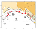
Figure 2, click
image to enlarge
Biennial bottom trawl surveys conducted in the Gulf of Alaska by NMFS are the primary fishery-independent data source used for estimation of commercial groundfish abundance. A persistent difficulty in the accurate estimation of groundfish biomass using trawl surveys is the unknown (but presumed large) amount of the continental shelf that is not fishable with standard survey gear. These surveys follow a stratified-random sampling design but involve substantial areas that cannot be sampled with standard survey trawls due to characteristics of the seafloor.
Many of these areas have been identified while searching for trawlable bottom during the standard trawl surveys, but these efforts suffer from two problems. First, because survey stations are defined by a 25 km2 grid superimposed on the survey strata, the data collected to date do not allow sufficient granularity to examine trawlability on a fine scale. Second is the subjective nature of the designation process for untrawlable bottom.
Different observers, with varying levels of experience in overall bottom trawling and use of the survey net and using different acoustic systems, make subjective decisions about the reasonable probability of completing a successful observation at a particular station. Inevitably, this leads to intervessel and interannual differences in the results of this process. To address these problems, a more objective and fine-scale method of evaluating the trawlability of the bottom with respect to the standard survey net is desirable.
The main impetus for the April 2007 cruise was to evaluate the utility of acoustic and ancillary data in the development of a more objective method of determining bottom trawlability. The scientific objectives of the cruise included estimating the critical angle differentiating trawlable and untrawlable bottom; evaluating the ability of split-beam echosounders to detect slopes in both alongship and athwartship directions and to detect substrate hardness/roughness; investigating the effect of water depth on perception of slope; examining how the interplay between hardness and roughness affects trawlability; evaluating the importance of heave, pitch, and roll data on acoustic data quality in the estimation of trawlability; and evaluating how the use of multiple frequencies improves the estimation of trawlability.
All operations were conducted 11-23 April aboard the NOAA ship Oscar Dyson. Multiple-
frequency acoustic data were collected continuously along a series of transects with a Simrad ER60 echo sounder system incorporating five centerboard-mounted transducers at 18 kHz, 38 kHz, 70 kHz, 120 kHz, and 200 kHz. A drop camera system with strobe lighting was used for video validation of acoustic backscatter data.
Nearly the entire cruise time was spent conducting over 3,000 km of acoustic transects over areas of interest (Fig. 2). All of the planned transects in Kasaan and Glacier Bay were completed. The remaining time was spent conducting acoustic transects over historical tow and search paths in offshore waters, while slowly transiting towards Kodiak. All together, more than 50 GB of acoustic data were collected for analysis. It is expected that these data will provide a rich source of information to meet the scientific objectives of the project. Data analysis will take place in the upcoming months.
Vessel motion data were successfully collected throughout the cruise as well. A total of 13 conductivity-temperature-depth (CTD) casts were made. The camera work was very successful on the first deployment, capturing outstanding video images of the seafloor, but the camera system subsequently failed and could not be repaired in the field.