Cetacean Assessment and Ecology Program
Cook Inlet Beluga Habitat Analysis
 |
|
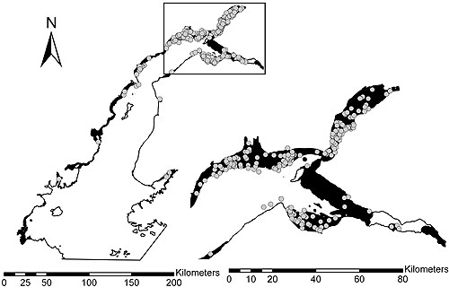
Figure 1. Cook Inlet beluga habitat (black) predicted by the Resource Selection Function model
with beluga sightings shown in gray. The right side of this figure shows a magnification of the boxed area. |
More than half of Alaska’s residents live in the area immediately surrounding Cook Inlet, a semiconfined body of water
which is home to a small, isolated population of beluga whales. With less than 300 animals remaining, the Cook Inlet beluga
population is susceptible to local physical, ecological, and anthropogenic stressors. Current plans to further develop
portions of Cook Inlet make identifying habitat requirements particularly timely for this beluga population.
Geographic information systems (GIS) and various statistical techniques are powerful tools that have helped elucidate the
relationship between several environmental parameters and the summer distribution of beluga whales. Classification and
regression tree (CART) and resource selection function (RSF) models were used to determine the ecological importance of
bathymetry as well as the distance from river inlets (categorized as low, medium, or high according to rate of river flow)
and proximity to mudflats.
The CART model provided insight on the underlying structure of the data while the RSF model allowed environmental
variables to be assessed individually based on the level of significance. The importance of the rate of river flow varied
slightly between the models, but in general belugas preferred to be near higher flow rivers and proximate to mudflats. Using
GIS to map the results from the RSF model resulted in a spatial depiction of available beluga habitat (Fig. 1 above).
In addition to the environmental factors already being examined, proposals are underway to examine biological factors
(such as prey availability) as well as anthropogenic factors that may be influencing the distribution of belugas in Cook
Inlet. In the future, we hope to increase the predictive power of habitat models by accounting for activities such as
fishing, oil and gas activity, military action, and transportation. Overall, the current and future work involved in
determining beluga habitat provides an example of how the interdisciplinary integration of GIS and statistical modeling
can reveal important aspects of the habitat requirements of this depleted stock of whales.
By Kim Goetz
 |

|
OND2005 quarterly sidebar
AFSC Quarterly
Research Reports Oct-Dec 2005
Contents
Feature
ABL Reports
FMA Reports
NMML Reports
RACE Reports
REFM Reports
Milestones
Quarterly Index
Quarterly Home
|

