|
|
| Error processing SSI file |
|
||||
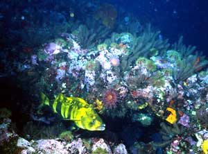
Groundfish Assessment:Identification and Characterization of Atka Mackerel Reproductive Habitat
Figure 1. A bright yellow male Atka mackerel guards clutches of eggs at a nesting site near Seguam Island in 25 m of water. In late spring, males aggregate in near shore nesting areas throughout the Aleutian Archipelago and guard nests through late fall. This picture was taken as part of an AFSC study characterizing Atka mackerel reproductive habitat. Atka mackerel is 1 of 10 species of hexagrammids that are endemic to the North Pacific Ocean. Although not a scombrid or true “mackerel,” it is valued as a food fish. Atka mackerel’s schooling behavior is uncharacteristic of hexagrammids and its high abundance in the Aleutian Islands region supports a multimillion dollar annual commercial trawl fishery. Historical accounts and fish bones from Aleut middens indicate Atka mackerel was also an important subsistence fish for indigenous populations. Furthermore, larval, juvenile, and adult Atka mackerel play a key role in the marine ecosystem as an essential forage species for planktivores, marine birds, picsivorous fishes, and marine mammals, including the endangered Steller sea lion. Despite its ecological, commercial, and anthropological value, the basic biology of Atka mackerel is not well understood. Major research efforts currently focus on offshore waters where a large percentage of the Atka mackerel population lives a semipelagic existence during much of the year. Of particular interest to behavioral and stock assessment biologists, however, is the Atka mackerel’s annual spawning migration. Males move to nearshore areas of the Aleutian Islands during the early summer and establish nesting sites where females come to lay eggs, after which males guard the nests. Since surveys of nesting sites in the Aleutian Islands region have never been done, it is unknown to what extent Atka mackerel utilize the nearshore habitat surrounding the islands or deeper offshore areas where the commercial fishery operates.
In terms of managing this species, knowing more about its reproductive ecology seems prudent. The potential impact of trawl fishing on the population cannot be assessed without first understanding annual migration patterns or the spatial extent of nesting sites. Understanding annual migration patterns should be an essential first step for developing a strategy for estimating the abundance of Atka mackerel. Also critical is knowledge of how spawning habitat overlaps with the commercial fishery. Nest or nesting habitat destruction by commercial trawls or direct removal of guardian males during the nesting period could adversely impact survival of embryos and ultimately the population. This study was the first to locate and characterize an Atka mackerel nesting area in the U.S. EEZ. In the nearshore areas of Finch Cove, Seguam Island, we were able to estimate clutch density and document on video the behavior associated with courtship, spawning, and nest guarding (Fig. 1). In 2002, the chartered fishing vessels Morning Star, Sea Storm, and the USFWS research vessel Tiglax were used as support vessels for further investigation of Atka mackerel nesting habitat. On 31 May an in situ time-lapse camera was deployed at the Finch Cove nesting site before male Atka mackerel were present. Footage from the retrieved video camera revealed that an aggregation of males established the nesting site in mid-June. Clutches of eggs were present, and males were still exhibiting nest fidelity when a time-lapse camera was last reset on 31 August. The camera will continue to sample daily footage for 1 minute per day through December 2002 so that we can observe when males finally depart the nesting site. Temperature, current, and depth data loggers attached to time-lapse cameras will be used to see how utilization of the nesting habitat varies with changes in the physical environment. At the same site, two 30-m scuba transects were established to count clutches to see how the number varied over time. The number of egg clutches was 0 in May and peaked at 30 clutches in late August. One freshly laid clutch of eggs and several of unknown age were sampled at the beginning of August. These eggs are being incubated at the AFSC in a controlled environment similar to what is found at the nesting site. The resulting developmental series will be a useful tool for estimating the age of egg samples obtained from clutches at various nesting sites. In this way we can estimate how long males would have to remain at the nesting site assuming they stay until all eggs are hatched. To expand our capabilities for searching, verifying, and quantifying Atka mackerel reproductive habitat, we developed the Quadrat Underwater Assessment Drop Camera (QUADCAM) in 2001. The QUADCAM collects sequential still photographic images of a fixed area (0.25 m2) using a digital video camera. The new camera system was deployed successfully this summer using a 16-ft inflatable skiff outfitted with a portable winch and boom. Images from the digital video camera were clear and detailed. A real-time navigation camera connected to a topside monitor was used to navigate the QUADCAM along bottom so it would not hang up. In over 200 drops in depths ranging from 15 to 160 m, the QUADCAM photographed two Atka mackerel egg clutches. Still photographs will be used to describe the physical and biological characteristics of the nesting habitat. Several deployments were made in Seguam Pass to depths below 150 m and one in Amukta Pass to 100 m. The bottom was prolific with colorful corals, sponges, and other invertebrates, and great numbers of Atka mackerel were seen scattered along the bottom. On the deeper deployments, no egg clutches were observed, nor were male Atka mackerel exhibiting nesting behavior. In shallower deployments, it was observed that nesting male Atka mackerel reacted to the QUADCAM’s strobe lights. A low density of egg clutches, a small area of coverage of the QUADCAM, or both probably accounted for the low number of clutches observed. Egg clutches on vertical faces or under ledges would also be hard to detect. After trying a variety of methods, we decided the best and quickest means for documenting nesting sites was to use a regular drop camera without lights. The drop camera did not affect behavior and we were able to use it to locate aggregations of brightly colored yellow males. These males exhibited the typical nesting behaviors we documented using time-lapse cameras, hence, we were able to use them for identifying nesting sites. Using this methodology, we located other nesting areas within the Aleutian Islands region including: 1) Austin Cove and Chighagof Harbor on Attu Island, 2) northwest corner of Buldir Island, 3) western side of Amukta Island, and 4) Wharf and Lava Points on Seguam Island. Nesting sites were absent at many areas adjacent to these as well as other areas including Sweeper Cove on Adak Island, south end of Kagalaska Island, Umak Island, and Kasatouchi Island. At all sites, temperature, depth, and position data were collected with the camera drops for comparing the physical and biological environment.
By Bob Lauth and Scott McEntire. Bottom Trawling Research and Reconnaissance
Surveying in Bristol Bay Upon completion of the bottom trawl study, a reconnaissance survey of Bristol Bay habitats was undertaken using the Klein 5410 side- scan sonar. This system is new technology that not only produces extremely high-resolution images of the seafloor, but also simultaneously gathers swath bathymetry data using interferometry. Approximately 1 megabyte (MB) of data are collected each second. Prior to deployments in Alaska, the research team developed an improved software interface during laboratory testing and sea trials in Portsmouth Harbor, New Hampshire, and Puget Sound, Washington. The reconnaissance effort was centered on an 800 mi2 area of central Bristol Bay that has never been hydrographically surveyed by NOAA. Bathymetric data and imagery were collected along survey lines totaling nearly 600 linear miles. In support of coordinated Essential Fish Habitat (EFH) characterization studies in the area, the reconnaissance survey intentionally crossed 18 RACE Division trawl survey stations and followed 78 mi of seabed previously classified using a QTC View single beam acoustic system. The survey also intersected six of the trawl study corridors (above) in order to provide a spatial context for these experimental results. Overall, a great diversity of complex sand-bedforms and other geological features were encountered in the survey area. By Bob McConnaughey. |
|
AFSC Quarterly Feature Auke Bay Lab National Marine Mammal Lab RACE Division REFM Division Quarterly Index Quarterly Home |
||
|
|
||||
|
|
||||