|
|
| Error processing SSI file |
|
||
Mechanism for Transport Of Oil-Contaminated Groundwater Into Pink Salmon Redds
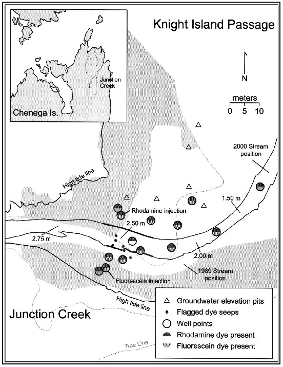
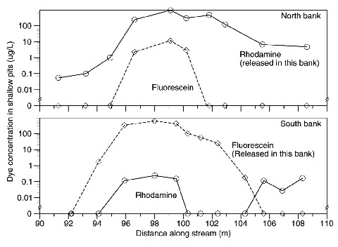
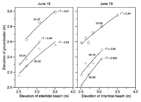
Figure 1. Junction Creek, Chenega Island, Prince William Sound, Alaska: tracer dye detection area, wellpoint installations, dye injection points, and groundwater elevation pits. Small dots indicate locations where dye was observed upwelling from sediment into stream water (a minority of such observations were mapped). Vertical streambed elevations are indicated (meters above mean lower low water). Shaded areas approximate oil distribution in 1989. The intertidal beaches of Prince William Sound (PWS), many of which were oiled as a consequence of the Exxon Valdez oil spill, serve as spawning habitat for pink salmon. The flowing freshwater of these streams prevented oil from depositing directly into the stream channels, but the presence of elevated cytochrome P4501A enzyme activity in pink salmon alevins from streams adjacent to oiled beaches suggests transport of oil-contaminated groundwater into pink salmon egg redds. In response to the oil spill, a study was designed by ABL scientists 1) to determine if groundwater from intertidal beaches does flow into streambed gravel where pink salmon eggs incubate and 2) to elucidate the mechanism for this movement should it occur. Groundwater movement was determined by release of fluorescent tracer dyes in beaches surrounding two PWS streams: Junction Creek and Sleepy Creek. Measurements were made of groundwater elevation as tides ebbed which were related to changes in groundwater salinity and temperature to tidal cycles. Intertidal areas around both streams were heavily oiled in 1989, and both streams support pink salmon populations. Fluorimetric tracer dyes injected into gravel beaches surrounding streams during ebb tides were rapidly observed throughout most of the intertidal portion of each watershed, including water below stream channels (Fig. 1). Within half an hour, dyes were observed upwelling from streambed gravel into stream water. Mean horizontal groundwater flow rates were rapid (4-7 m h-1), as expected for sand and gravel beaches with high hydraulic conductivity, and were driven by hydraulic gradients within beach groundwater. Dyes were consistently detected in wellpoints located in the hyporheic zone (the boundary area of water between the stream bed and groundwater) and in surrounding beaches. At Junction Creek, where different dyes were simultaneously released on opposite sides of the creek, each dye was detected in the beach opposite release within the first tidal ebb (3 h; Fig. 2). Dyes remained detectable in subsequent tidal cycles (observations were discontinued after 2 or 3 cycles), and dye was forced vertically uphill by tidal action (0.5 m elevation increase, the upper extent of observations). Groundwater elevations were correlated with sediment elevation, providing evidence of the hydraulic gradient responsible for lateral subsurface water movement (Fig. 3). The flow of groundwater containing polycyclic aromatic hydrocarbons (the primary toxic components in crude oil) dissolved from oiled intertidal beaches surrounding anadromous streams into the hyporheic zone caused pink salmon eggs to became contaminated after the Exxon Valdez oil spill. Aliphatic and aromatic hydrocarbons dissolve into water surrounding oil-coated sediment at rates related to the energy required for escape, and the resultant contamination is sufficient to cause toxicity. The presence of toxic concentrations of hydrocarbons in the hyporheic zone resulted in cytochrome P4501A activity noted in pink salmon eggs from oiled streams and reductions in embryo survival in the years following the spill. Stream substrate characteristics selected by spawning adult pink salmon and required for successful incubation of eggs (including high porosity and water exchange) are the same characteristics that permit contaminated water ready access to the eggs. Studies in 2002 continue to find persistent oil at many sites within PWS.
Bering-Aleutian Salmon International Survey (BASIS), September 2002The Bering Sea provides important rearing habitat for juvenile, immature, and maturing salmon (Oncorhynchus spp.) from North America, Japan, and Russia. However, recent unexpected reductions in commercial and subsistence salmon fisheries in Asia and North America appear to be linked to changes in Bering Sea productivity. To address this concern, the North Pacific Anadromous Fish Commission (NPAFC) initiated a large-scale, long-term cooperative international salmon and ecosystem research program called the Bering-Aleutian Salmon International Survey (BASIS). This research program is intended to serve as a vector for data sharing among nations, to provide comparative studies of salmon growth and survival from the eastern and western Bering Sea regions, and to provide a comprehensive picture of salmon ecology in the Bering Sea and Aleutian Islands regions. As part of BASIS, the Ocean Carrying Capacity (OCC) Program participated in a large-scale salmon survey in the central and eastern Bering Sea during September through early October 2002. The OCC Program chartered the fishing vessel Northwest Explorer to conduct the U.S. BASIS survey, and sent scientists onboard the Japanese BASIS vessel Kaiyo Maru and the Russian BASIS vessel TINRO. Stock identification data were collected aboard all three vessels to assist in the construction of migratory models of salmon stocks. Stomach and muscle tissue samples were collected for diet and lipid studies, and scales and otoliths were collected for age and detailed growth studies. Seventeen immature chum salmon were tagged from the Kaiyo Maru and released with temperature and depth recording tags. Joint trawling was completed by BASIS vessels at 12 stations in the central Bering Sea during 12-17 September 2002. Immature salmon and young-of-the-year Atka mackerel (Pleurogrammus monopterygius) were the two primary species caught during the trawl comparisons. The Northwest Explorer had a higher average catch rate for salmon and a lower average catch rate for Atka mackerel. These differences are thought to be largely due to the shallower sampling depth of the trawl used by the Northwest Explorer. Similar sampling depths by all three vessels may be required to ensure catch rates that are comparable between the individual BASIS surveys. The U.S. and Japanese vessels fished side by side at six stations and were joined by the Russian vessel at a seventh station. Each vessel towed its trawl for 1 h at 5 knots using their standard fishing technique. Catches of salmon and Atka mackerel differed between the Japanese vessel (623 salmon and 66,089 Atka mackerel), and the U.S. vessel (205 salmon and 5,901 Atka mackerel), possibly due to the vertical spread of the Japanese trawl being twice that of the U.S. trawl. Tissue samples from sockeye salmon (O. nerka, n=247) and chinook salmon (O. tshawytscha, n=237) were collected for genetic analysis to determine migration routes, and stomach samples (n=352) were collected for food habit and bio-energetic modeling. Seventeen salmon were tagged and released with temperature and depth recording tags for behavior, bio-energetic, and migratory studies. The Japanese sampling protocol included information on micronekton, zooplankton, oceanography, acoustics, current direction and speed, solar radiation and weather, as well as nutrients, scales, otoliths, lipids, parasites, and molecular neuro-endocrine information on salmon. By Ellen Martinson.
Radio-tagging Study on Yukon River Chinook SalmonA basinwide radio tagging study was conducted on Yukon River chinook salmon in 2002 by the National Marine Fisheries Service and the Alaska Department of Fish and Game (ADF&G). Chinook salmon returns to the basin support important commercial and subsistence fisheries in the United States and Canada. These fisheries have been the focus of numerous disputes over harvest allocations between the two countries. Chinook salmon returns have declined dramatically in recent years, and information is needed to facilitate conservation efforts and improve management.
The primary objectives of the study were to provide detailed information on the movements, timing and spawning distribution of chinook salmon stocks and to help evaluate run assessment programs in the basin. Adult chinook salmon were captured in the lower river near the villages of Marshall and Russian Mission and tagged with radio transmitters. Fish moving upriver were recorded by remote tracking stations located throughout the basin on important travel corridors and spawning tributaries. Aerial tracking surveys were also flown to obtain detailed movement and distribution information in spawning areas. An automated database and geographic information system (GIS) mapping program was used to summarize telemetry data in season to provide resource managers with updated information. Work on an Internet link to the database was also completed and used during 2002, although modifications are needed to make the system usable by the general public. Approximately 800 chinook salmon were tagged during the study. The fish responded well to the capture and tagging procedure, with over 97% resuming upriver movement. Chinook salmon traveled to areas throughout the drainage, providing detailed information on stock composition and timing. This information was particularly useful in addressing questions regarding in-season management resulting from conflicting data from run assessment projects in the basin. Fish traveling to upper reaches of the basin were predominant throughout the run. Most of these fish returned to the upper Yukon River and were comprised of U.S. and Canadian stocks, although Tanana River fish were also an important component. Fish traveling to lower and middle reaches of the drainage were present throughout the return but were more prevalent late in the run. Migration rates for upriver fish averaged 53 km/day, with some stocks exhibiting rates of over 66 km/day. Fish traveling to areas in the lower basin exhibited significantly slower migrations rates. Twenty-three chinook salmon were tagged with radio-archival tags that recorded depth and water temperature as the fish moved upriver. Eighteen of these tags were recovered and provide new insights into fish behavior and movement patterns in different reaches of the basin. In addition to the information provided on chinook salmon, the study demonstrated that basin-wide radio-tagging programs are feasible for other species in large, remote drainages. By John Eiler.
|
|
AFSC Quarterly Feature Auke Bay Lab National Marine Mammal Lab RACE Division REFM Division Quarterly Index Quarterly Home |
|
|
||
|
|
||