Groundfish Assessment Program
Manned Submersible Studies in the Gulf of Alaska
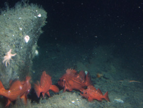
Figure 4. School of rougheye rockfish (Sebastes aleutianus) in boulder/cobble habitat.
Photo from Albatross Bank survey.
|
|
ABL researchers completed two surveys in the Gulf of Alaska during summer 2005 using the two-person submersible Delta, which was
launched from the support vessel Velero IV. The first survey was located on Albatross Bank southeast of Kodiak Island during 22 June
to 2 July, and the second survey was in the Cape Ommaney and Hazy Islands vicinity off southeastern Alaska from 20 July to 1 August.
The purpose of the Albatross Bank survey was to perform a rockfish catchability experiment and to sample geologically-based habitats on
previously mapped areas in this vicinity. The primary objectives were to 1) sample a glacial outwash habitat type to estimate survey gear
catchability, and 2) groundtruth multibeam-derived habitat types on three sites along Albatross Bank. Survey participants were Kalei
Shotwell (chief scientist from ABL), Dana Hanselman (research biologist from ABL), and Sean Rooney (graduate student from the University
of Alaska Fairbanks).
A total of 24 dives were completed during the cruise, most of which were in the “Snakehead” area of the bank. Eight of these dives were
on outwash habitat to estimate catchability, and 11 were on other habitat types for groundtruthing. Dives were also completed on two of
the bank’s pinnacles: two dives on “49 Fathom” pinnacle and one on “8 Fathom” pinnacle. Finally, two dives were inshore dives during poor
weather near Two-headed Island near the southwest end of Kodiak Island. Transect lengths were usually about 1,800 m. For each dive,
researchers recorded audio and video from two camera angles and collected conductivity-temperature-depth (CTD) data (usually from start
to finish). Twenty-nine additional CTD casts were completed as time allowed.
For the catchability experiment, researchers coordinated with the chartered vessel Sea Storm, which was conducting a biennial trawl
survey for the AFSC Resource Assessent and Conservation Engineering (RACE)
Division. Scientists aboard the Sea Storm conducted four trawl hauls in areas that were surveyed with the Delta.
Video was recorded of juvenile rockfish on several habitats, particularly moraines, bedrock-like exposures, and bedrock ridges. Gravid
sharpchin (Sebastes zacentrus) and yelloweye rockfish (S. ruberrimus) were observed as well as rougheye rockfish
(S. aleutianus) schooling behavior and multiple color morphs (Fig. 4 above). Several large schools of rockfish were noted by the
submersible observer (e.g., dusky rockfish, S. variabilis) and a particularly active and large Pacific ocean perch (S. alutus)
school was recorded on video in sandy mud habitat with occasional sea whips.
The purpose of the Cape Ommaney and Hazy Islands survey was to sample geologically-based habitats that had been previously mapped in
this area by multibeam technology. The primary objectives were to characterize benthic habitat for juvenile rockfish and to groundtruth
the multibeam-derived habitat types. In addition, a few dives were conducted to gain further information on trawl survey catchability.
Survey participants were Jon Heifetz (chief scientist from ABL) and Kalei Shotwell (research biologist from ABL).
A total of 33 dives were completed during the survey. Twelve of these were on the Hazy Islands mapped site, one of which was for
estimating catchability ability. Nine dives were completed on the Cape Ommaney mapped site, and two of these were for estimating
catchability. The remaining 12 dives were conducted during a period when sea conditions were unfavorable for sampling the mapped
areas, which were all located in offshore waters. These remaining dives were completed inshore in the vicinity of the mapped sites
off the southern end of Baranof Island and outside of Craig, on Prince of Wales Island. Two of the inshore dives were completed off
Coronation Island, four in the Gulf of Esquibel, four in Whale Bay, and two in Big Branch/Little Branch Bay.
Researchers coordinated with the Sea Storm for the catchability dives. Scientists from the Sea Storm completed two
hauls off Cape Ommaney near the dives sites (where they caught a large number of Pacific ocean perch) and attempted one unsuccessful
haul off the Hazy Islands.
Juvenile rockfish were recorded on several habitats, particularly granite rock exposures and highly-fractured glaciated rock.
Researchers observed large schools of juveniles in high relief habitats (e.g., boulder, rock outcrops) and fewer solitary individuals
hiding in sponges and under rocks in the low relief habitats (e.g., flat pavement, hummocky sediments). Many gravid females occurred
on rocky habitats; these fish included sharpchin, redstripe (S. proriger), redbanded (S. babcocki), greenstriped
(S. elongatus), and pygmy (S. wilsoni) rockfish. Inshore habitats had a large diversity of rockfish, and many
juveniles were seen mixed with adults.
By Kalei Shotwell
>>>continued
 |

|
JAS2005 quarterly sidebar
AFSC Quarterly
Research Reports July-Sept 2005
Contents
Feature
ABL Reports
FMA Reports
NMML Reports
RACE Reports
REFM Reports
Items
Quarterly Index
Quarterly Home
|
