|
|
| Error processing SSI file |
|
|||||||
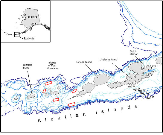
Groundfish AssessmentJuvenile Pacific Ocean Perch Research in the Aleutian Islands
Two research cruises aboard the Ocean Explorer were completed by Groundfish Assessment Program scientists during summer 2004 to map and study juvenile Pacific ocean perch (POP) habitat. The research was conducted around Samalga Pass and the Islands of Four Mountains, in the eastern half of the Aleutian Islands archipelago (Fig. 2 above). The goal of this study was to assess the value of AI habitat to juvenile Pacific Ocean perch (POP). The specific objectives of this research were to 1) map five study areas using multibeam and sidescan sonar and groundtruth these acoustic observations; 2) model relationships between juvenile rockfish abundance and habitat characteristics, such as depth, slope, temperature, sponge and coral abundance; and 3) link the habitat to the condition of juvenile rockfishes by determining if energetic content of juvenile rockfish is similar in different habitats.
During the initial cruise, beginning and ending in Dutch Harbor, Alaska, (28 May to 9 June 2004) habitat mapping
was completed. Current speeds were high around the islands and passes (exceeding 6 knots), which slowed the
mapping progress. Each of the five study areas surrounding the Islands of Four Mountains was mapped using towed
side-scan sonar (Klein 3000) and multi-beam sonar (Simrad SM2000) systems. These instruments collected bathymetry
and reflectivity data using sound characteristics reflected from the seafloor. This acoustic data was geo-referenced
using an ultra-short baseline (USBL) tracking system to pinpoint the exact position of the bottom information.
Acoustic data collection and tracking were performed by technicians from the U. S. Naval Undersea Warfare Center
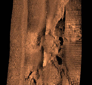
(NUWC), Keyport Washington. Much of the data processing was completed aboard the Ocean Explorer and mosaics
were produced that depicted bottom depth and roughness (i.e., Fig. 3). In total, 25 km2 were mapped using side-scan
sonar, and multi-beam data was collected over almost twice that area.
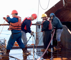
The second cruise (12-23 August 2004) benefited from excellent weather for 6 days that allowed researchers to make
substantial progress in meeting project objectives. Researchers concentrated on completing underwater video
collections and sediment sampling to verify acoustic habitat maps produced during the first cruise. The underwater
video system was towed behind the research vessel from 1-2 m off the seafloor, and technicians from the NUWC used
a USBL system to geo-reference the video camera position (Fig. 4). Video was collected at 12 transects in three of
the study areas that bisected interesting areas from the multibeam and sidescan sonar mosaics. Scientists viewed the
video feed aboard the research vessel in real time which allowed areas with juvenile POP present to be located using
the camera system. Preliminary results indicate habitats sampled at each area varied widely, from bare sand fields
to rocky ledges, ridges and pinnacles. Sponge and coral were the dominant epibenthic invertebrates observed in the
video and trawl collections, although diversity in benthic organisms was quite high at some sites.
|
|
AFSC Quarterly Research Reports July-Sept 2004 ContentsFeature ABL Reports NMML Reports RACE Reports REFM Reports Quarterly Index Quarterly Home |
|||||
|
|
|||||||
|
|
|||||||