Polar Ecosystems Program
Harbor Seal Surveys in the Aleutian Islands
Staff from the Polar Ecosystem Program (PEP) successfully completed aerial surveys of harbor seals
in the Aleutian Islands, from Unimak Pass out to the Near Islands. Surveys of the Aleutian Islands
region present unique challenges due to the length of the island chain (nearly 1,400 miles) and
large-scale convergence of atmospheric and oceanographic fronts which commonly produce dense fog and
inclement conditions (i.e., low visibility and turbulence). These surveys, conducted over a different
segment of the Alaskan harbor seal range each year, provide an estimate of the minimum abundance of
animals hauled out during low tide when peak numbers of seals typically haul out. These estimates will
be adjusted upward to account for seals that remain at sea (and not counted) according to the haul-out
behavior measured at representative sites. The final estimates are used to update stock assessments
required under the Marine Mammal Protection Act.
During 5-15 August 2004, observers in four twin-engine planes, two based in Dutch Harbor (NOAA’s Twin
Otter and a Grumman Goose seaplane) and two on Adak Island (two turbine Aero Commanders), conducted
surveys daily for a maximum of 4 hours centered on low tide. Observers took digital images of the
larger seal haul-out sites that were too difficult to estimate visually. By using digital cameras
linked to a GPS, very precise locations of the haul-out sites were recorded and archived with the
images. This allows for more accurate counting by eliminating errors that may occur when tallying
counts within a specific area. This year, the weather was especially problematic, causing several
ground days, long transits with no breaks in the clouds or fog, and the use of alternate airports.
Despite the weather, virtually all previously mapped haul-out sites were visited at least once and
many up to three times. Reconnaissance of new haul-out sites was also completed for all but a few
segments of coastline.
Due to the anticipated poor weather and remoteness of the survey area, a new technology was tested
in order to provide an extra margin of safety. Automatic Flight Following (AFF) was used on two
aircraft that were assigned routes requiring long transits over open water. This allowed survey
coordinators in Anchorage and Seattle to follow aircraft in real time, thereby reducing the response
and search times should a plane have encountered problems. The AFF hardware that was installed relayed
position, altitude, speed and direction information every 2-3 minutes to a secure web-based tracking
program. The two aircraft without AFF hardware used satellite phones to report status and position at
regular intervals.
By Dave Withrow and John Jansen
Habitat Use and Diving Behavior of Harbor Seals in Cook Inlet, Alaska
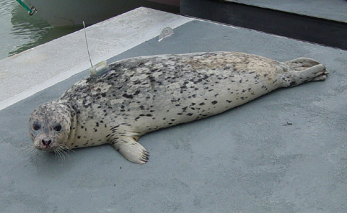
Figure 1. Harbor seal with satellite-linked dive recorder about to be released in Cook Inlet, AK.
The Polar Ecosystems Program (PEP) initiated a third project in a study of harbor seals in Cook Inlet,
Alaska, under an Interagency Agreement with the Department of Interior, Minerals Management Service
(AFSC Quarterly Reports
April-June 2003,
October-December 2003,
January-March 2004,
April-June 2004).
The new project uses satellite-linked dive recorders (SDRs) that provide information on diving behavior
and locations of the seals at sea and ashore. Between 26 August and 4 September, PEP researchers worked
from a charter vessel using nets and small boats to capture 34 harbor seals at five locations in Cook Inlet
and Kachemak Bay. SDRs were attached to the pelage of 19 of the seals that had completed their annual molt
(Fig. 1 above).
Data from these SDRs will be used to: 1) investigate marine habitat use and diving behavior by seals,
and 2) correct abundance estimates for the proportion of seals that are at-sea and not counted during
aerial surveys. This proportion, and its relationship to date, time of day, tides, and weather, is a
fundamental element of estimating the abundance of harbor seals. However, the proportion missed has
been extremely difficult to estimate in surveys of harbor seals in Alaska and elsewhere, conducted during
the seal’s molting (peak haul-out period). During the molt, instruments that record haul-out behavior
will not remain attached to the seals’ pelage. One of the key features of the Cook Inlet studies that
will allow a new method of estimation is that aerial surveys and estimates of the haul-out proportion
will be available from multiple dates throughout the annual cycle. This will allow comparison of
estimates from different times of the year to test whether historical estimates from the molt period
are accurate. A total of 70 SDRs will be deployed in May and September of 2005-2006.
By Peter Boveng

|

|
Quarterly sidebar
AFSC Quarterly Research Reports July-Sept 2004
Contents
Feature
ABL Reports
NMML Reports
RACE Reports
REFM Reports
Quarterly Index
Quarterly Home
|
