Polar Ecosystems Program
When the Ice Is Gone, Where Will the Seals Go?
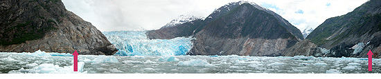
Figure 4. Image of South Sawyer Glacier (in Tracy Arm) June 2005. Glacial areas
like this are important to harbor seals which pup and nurse their young on these ice
flows. The arrows indicate the extent of the glacier in June of 2004, which has receded
nearly 2 kilometers in just the last year and the width reduced by about two-thirds. |
There are more than 100,000 glaciers in Alaska
covering 5% of the total land mass; most, however, are in rapid retreat.
In 1983, there were 52 recorded tidewater glaciers (terminating in the
ocean) in Alaska; in 2004 we documented 31 remaining and all but about 5
were receding. Harbor seals use the floating ice calved from at least 17
of these glaciers, which seem to provide relatively safe locations for
the seals to pup, nurse their young, and molt, free from most predators
and disturbance. Haul-out space on the floating ice is nearly always
available and is independent of tide height.
Recent concerns for seals have arisen due to increased vessel traffic
and disturbance by sightseeing and cruise ships in several tidewater
glacial regions. The PEP is conducting research in collaboration with
Alaska Native groups and the cruise ship industry to understand and
mitigate the impact of this traffic on harbor seals in glacial areas.
Each spring since 1998 to the present, Dave Withrow has censused three of the
main glacial pupping areas in Southeast Alaska: Tracy Arm (Sawyer Glacier),
Endicott Arm (Dawes Glacier), and LeConte Glacier. The seals at these sites
have been composed almost entirely of mother-pup pairs. In June 2005, the Sawyer
Glacier, which had been steadily decreasing by only tens of meters each
year, was found to have receded by approximately 2 kilometers since 2004
(Fig. 4, above). The width of the glacier (at sea level) was reduced
approximately 66%. If this retreat continues at its current rate, the
Tracy Arm will no longer have a tidewater glacier within a year or two.
The reduction of prime pupping habitat could have a significant impact
on harbor seal populations in Alaska.
Detailed information on this research will be presented in December at the
16th Biennial Conference on the Biology of Marine Mammals in San Diego, California.
Capture Studies in Cook Inlet
From 28 April to May 14, members of the PEP
participated in a harbor seal (Phoca vitulina) capture trip in
lower Cook Inlet. The purpose of the trip was to practice capturing
seals over a wide area in preparation for a much larger operation
planned for September 2005. Seals were weighed and measured, and
satellite transmitters were attached in order to track their movements
over time. The research was funded by the Department of the Interior’s
Minerals Management Service, which is interested in collecting baseline
information on harbor seals prior to proposed oil development in the area.
Habitat Use of Harbor Seals in Berner’s Bay
Dave Withrow, along with Aleria Jensen and Erika Philips of the
Alaska Regional Office, transited to Berner’s Bay, Alaska, north of
Juneau aboard the NOAA vessel John N. Cobb. The purpose of the
trip was to examine the habitat use of harbor seals during the pupping
season. The Berner’s Bay region has gained much attention lately as
roads and bridges may be built soon, as well as increased barge and
vessel traffic, related to the reopening of a large gold mine in the
area and possible connection of Juneau with the rest of the Alaska
highway system. Dave Withrow also continued documenting harbor seal
pupping sites and making counts in Southeast Alaska.
By Dave Withrow
Continued Studies of Potential Disturbance of Harbor Seals by Cruise
Ships in Disenchantment Bay, Alaska
The PEP continued studies from 7 May to 8 June of
research conducted in
2002
and
2004 on the potential disturbance of
harbor seals by cruise ships in Disenchantment Bay, Alaska, during the
seals’ annual pupping season. Eleven aerial photogrammetric surveys were
conducted over the glacial ice field in Disenchantment Bay, where cruise
ship traffic is high during the tourist season. Eight surveys were
conducted in nearby Icy Bay, where cruise ships do not visit. Results
from the Icy Bay surveys will be used as controls from which to compare
results of the Disenchantment Bay surveys. This year, 12 additional
survey transects were added over the more populated half of each bay,
in-between the original 14 transects, in order to increase the sampling
coverage of the highly clumped seal distributions.
High-resolution digital survey images will be georeferenced in a geographic information
system (GIS) to enable mapping of the distribution and abundance of
harbor seals in each bay. Observers from the PEP and the Yakutat Tlingit
Tribe also boarded cruise ships entering Disenchantment Bay to record
ship movements via portable GPS (global positioning system) units, as
well as to count observed seal groups and measure their distance from
the ships. Spatial models of harbor seal abundance and distribution,
cruise ship movements, and glacial ice densities will be used to analyze
possible impacts of cruise ship traffic on the harbor seal population in
Disenchantment Bay. Similar efforts are planned for August 2005, during
the harbor seals’ annual molting period.
By Shawn Dahle, John Jansen, Jay Ver Hoef, and Elizabeth Beckman
 |

|
Quarterly sidebar
AFSC Quarterly Research Reports April-June 2005
Contents
Feature
ABL Reports
NMML Reports
RACE Reports
REFM Reports
Items
Quarterly Index
Quarterly Home
|
