| |
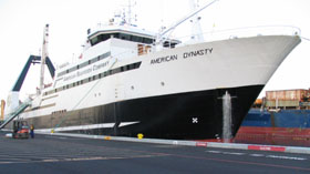
Figure 1. The 272 foot, 3,480 ton, factory trawler American Dynasty. |
Status of Stocks & Multispecies Assessment Program
Calibration of SIMRAD ES60 Echosounders
Commercial echosounder technology has advanced to the point where there is little difference in quality
between scientific echosounders and those used by the commercial fishing industry during fishing operations.
The AFSC in cooperation with the fishing industry and the Pollock Conservation Cooperative Research Center
(PCCRC) has begun a project to collect and store acoustics data collected by the fishing fleet during fishing
operations. These data will be used to investigate intra-annual movement and potential localized depletion of
pollock and Pacific whiting due to commercial fishing.
The first phase of the project was to design and implement a system which would collect data from the fishing
vessels with little to no impact on fishing operations. Since January 2002, we have successfully collected 1.2
terra-bytes of raw acoustic data from eight commercial fishing vessels equipped with SIMRAD ES60 echosounders
operating in the Bering Sea pollock and West Coast Pacific whiting fisheries. These data are from uncalibrated
echosounders and, therefore, cannot be used for quantitative biomass estimations.
The second phase of this project is to test whether we can successfully calibrate an ES60 echosounder to within
acceptable error bounds. On 18-19 June 2004, we conducted a calibration study in Elliott Bay, Washington, aboard
the American Dynasty, a 272 foot, 3,480 ton, factory trawler (Fig. 1 above). The calibration study was made
possible through funding by the Pacific Whiting Conservation Cooperative (PWCC), cooperation by American Seafoods,
and technical support from SIMRAD, the AFSC, and the NWFSC.
Preliminary work for the calibration began on 26 May 2004 when we conducted a site visit aboard the American
Dynasty to determine the optimum placement of the calibration equipment. We used downriggers equipped with line
counters and 100 lb Spectra line and modified their bases to fit onto the railings of the vessel.
On 9 June 2004, we employed a commercial diver to locate the transducer on the bottom of the vessel and provide
coordinates for the placement of the calibration sphere using the modified downriggers. The calibration team was
made up of five scientists from the AFSC: Steve Barbeaux, Martin Dorn, Matt Kookesh (Status of Stocks and Multispecies
Assessments Program), Chris Wilson, and Alex DeRobertis (MACE Program), one scientist from the NWFSC, Guy Fleischer
(Fisheries Resource Analysis and Monitoring Division), and one scientist from the PWCCRC, Vidar Westpestad.
 |
|
 |
|
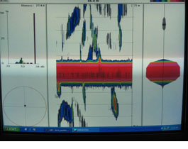
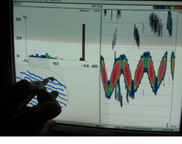
Figure 2. On-axis (left) and quadrants (right) data recording during calibration. |
The team boarded the American Dynasty on the evening of 18 June at the Rainier fuel dock while the
vessel was taking on fuel. We selected the Port of Seattle designated commercial anchorage area in Smith Cove on
the north end of Elliott Bay for the calibration site. Weather for the calibration was near perfect with little
wind (<5mph) and a slack high tide with a mean difference during the calibration of less than 2 feet. Upon entering
Smith Cove we determined that the amount of acoustic interference was within tolerance limits. We deployed a 60 mm
copper sphere using three of the modified downriggers and followed the standard calibration methods for the
calibration of acoustic survey echosounders (Fig. 2 above). We collected both on-axis and four quadrant data.
Recording began at 2:45 AM and finished at 4:25 AM. The vessel returned to Pier 90 in Seattle at 6:00 AM.
We are currently analyzing the calibration data. Another calibration exercise aboard the American Dynasty
is being scheduled for later in the summer in order to verify the stability of the commercial transducer. If these
calibrations prove successful, we will conduct similar calibrations over the next year on the other commercial
fishing vessels in our study.
By Steve Barbeaux and Martin Dorn
Update on Pacific Cod Localized Depletion Study
NOAA Fisheries scientists successfully completed fieldwork in this year’s localized fishing depletion experiment
in Alaska’s ‘cod alley’ near Unimak Island. At issue is whether commercial trawl fisheries affect food availability
for endangered Steller sea lions by creating a localized depletion of Pacific cod.
Researchers designed the localized depletion experiment in 2002 and 2003 under the Steller Sea Lion Research
Initiative to test for the presence of localized depletion effects from the winter trawl fishery on seasonal
aggregations of Pacific cod. The experimental design uses the 10 nmi, no-trawl boundary around Cape Sarichef on
Unimak Island to define “treatment” (subject to heavy trawl fishing during January-March) and “control” areas
(open to fixed gear, but closed to trawling). Both zones intersect a shelf area at 40-50 fathoms that has
historically been a popular cod trawling ground.
Researchers conducted surveys from a chartered fishing vessel both before the trawl opening in January and after
the main trawling season in late March. Researchers collected samples in January and March 2004 at 80 study stations,
40 inside the no-trawl zone and 40 outside the boundary. The experiment uses modified pot gear on short (4-8 hours)
soaks to measure local cod abundance. The goal of the experiment is a statistical test of whether the local abundance
in the trawled area declines relative to the control area.
The localized depletion experiment was also conducted in 2003. Results for that year were inconclusive because weather
and mechanical problems prevented collection of an adequate sample size in January. This past winter, both the January
and March cruises succeeded in sampling a full array of stations. Each station was sampled on 3-5 different days in
order to help smooth over short-term and tide-based variability. Researchers also collected biological data and
specimens being used in studies of genetic stock structure and reproductive biology.
Future plans call for a repeat of the experiment in 2005 and 2006 to test results over year-to-year variability in
weather, fishing, and the timing of cod spawning. Continuation of both the study and the special closure are contingent
upon continued funding of the study.
The North Pacific Fishery Management Council approved a special 2-week closure of the experimental area in support of
this research in fall 2002. The experimental area is to be closed to all fishing 15-31 March during the years when the
experiment is to be implemented (i.e., 2003 to 2006). The Council’s Scientific and Statistical Committee reviewed the
study design, and industry representatives cooperated in planning the closure request.
Researchers are also conducting a cod tagging study in the Cape Sarichef area, in order to learn more about the
short-term and seasonal movements of Pacific cod. Response to the cod tagging study has also been very positive, with
over 1,000 tags returned to the Alaska Fisheries Science Center.
Pacific cod tags are loop tags covered in either orange or hot-pink plastic and imprinted with a return address. The
reward for returning a cod tag, along with capture information, is a sharp-looking black baseball cap embroidered with
a custom “Cod Alley” design created by artist Ray Troll.
A limited number of electronic data storage tags, which have a cash reward of $200, have also been released. Results
of the tagging study are currently being analyzed. It is expected that these results will both aid in interpretation of
the local abundance data and provide new information about seasonal movements of cod on and around their spawning grounds.
Principal Investigators M. Elizabeth Conners and Peter Munro of the Alaska Fisheries Science Center presented the results
of this winter’s experiment to the North Pacific Fishery Management Council at the Council’s summer meeting in Portland,
Oregon in June 2004.
A detailed account of this research, from its beginning through 2003, is given in AFSC Processed Report 2004-04,
“Pacific Cod Pot Studies 2000–2003”. The document is available on the AFSC website at
http://www.afsc.noaa.gov/refm/stocks/fit/pot_cod.htm.
For further details, please contact Libby Logerwell, Fisheries Interaction Team Leader:
libby.logerwell@noaa.gov; Phone: 206-526-4231 / Fax: 206-526-6723.
By Peter Munro
>>>continued

|

|
Quarterly sidebar
AFSC Quarterly Research Reports Apr-June 2004
Contents
Feature
ABL Reports
NMML Reports
RACE Reports
REFM Reports
Quarterly Index
Quarterly Home
|
